This afternoon, as I drove along I-285 and US 19/GA 400, I saw a very special new roadsign...
Sandy Springs - City Limit (replacing the old signs that said "Sandy Springs - Unincorporated").
At 12:00 AM on December 1, 2005, Georgia's newest (and seventh largest) city, Sandy Springs, will be born.
Until now, Sandy Springs has been an unincorporated area within north Fulton County. As a result of ever-growing discontent with the Fulton County Government, the residents of Sandy Springs "seceded" from Fulton County via an act of the 2005 Georgia General Assembly and a referendum where the vast majority voted in favor of cityhood.
To read more about this history-making event, please click here.
Please join me in congratulating the citizens and leaders of the brand new City of Sandy Springs, Georgia. We here at "The Georgia Road Geek" wish them all the best in this history-making endeavor.
That's all for now. Thanks for visiting and please come back soon.
Wednesday, November 30, 2005
Monday, November 28, 2005
Get Your Official "Georgia Road Geek" Magnet

Be the first one on your block to sport an official "Georgia Road Geek" magnet (shown above) on your refrigerator, cubicle, or other place you like to stick magnets.
To order (limit one per request), please send a self-addressed stamped envelope (SASE) to the following postal address:
The Georgia Road Geek
P.O. Box 1002
Alpharetta, GA 30009-1002
INTERNATIONAL ORDERS: Please enclose either an International Reply Coupon or US$1.00 with your self-addressed envelope to cover postage and handling costs.
All requests will be processed ASAP, but please allow 4 weeks for delivery.
Thank you in advance for your request and always your support of "The Georgia Road Geek".
Wednesday, November 23, 2005
Happy Thanksgiving
Have a Happy Thanksgiving and may your travels be pleasant and safe.
Thanks for visiting and please do so often.
Thanks for visiting and please do so often.
Saturday, November 19, 2005
Interstate 14 - My Proposed Route
Last night, while visiting the Yahoo! Groups seroads discussion group, I went over to the link section and surfed the Alabama DOT (ALDOT) website.
While I was there, I noticed that ALDOT had a section regarding a proposal to extend I-85 from I-65 to I-20/59 along the US 80/AL 8 corridor.
According to the AARoads Interstate Guide website, this was supposed to be a part of a Congressionally proposed Interstate 14 corridor that would run through the "Black Belt" of Louisiana, Mississippi, Alabama, Georgia and South Carolina. Please click here for the proposal from the official website of Georgia Congressman Charlie Norwood.
For years before this proposal was made, I had originally envisioned Interstate 14, a route that would start at I-85 in eastern Alabama near Tuskegee, parallel US 80 from there to Phenix City, and into Georgia through Columbus, Macon/Warner Robins, and ending just west of Augusta at I-20 in Columbia County. This would be my own "Fall Line Freeway".
Based on ALDOT's proposed I-85 extension, I think it would make sense to keep it as part of the proposed I-14 corridor, with I-14 using the southern Montgomery bypass freeway (AL 108)as part of its route and I-14 and I-85 sharing pavement eastward until you reach the Tuskegee area. At that point, I-14 would run along a new route (parallelling US 80/AL 8) that would tie it into the existing Phenix City/Columbus northern bypass. Please click here for an ALDOT PDF file of the proposed I-85 extension study area.
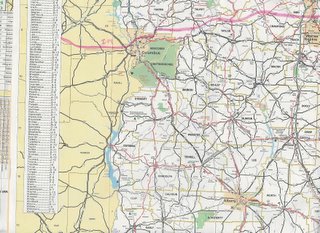
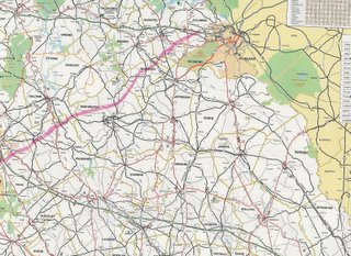
Here are images of my own I-14 Georgia route proposal as drawn on an official Georgia road map (my proposed route is in pink highlighter):
While I was there, I noticed that ALDOT had a section regarding a proposal to extend I-85 from I-65 to I-20/59 along the US 80/AL 8 corridor.
According to the AARoads Interstate Guide website, this was supposed to be a part of a Congressionally proposed Interstate 14 corridor that would run through the "Black Belt" of Louisiana, Mississippi, Alabama, Georgia and South Carolina. Please click here for the proposal from the official website of Georgia Congressman Charlie Norwood.
For years before this proposal was made, I had originally envisioned Interstate 14, a route that would start at I-85 in eastern Alabama near Tuskegee, parallel US 80 from there to Phenix City, and into Georgia through Columbus, Macon/Warner Robins, and ending just west of Augusta at I-20 in Columbia County. This would be my own "Fall Line Freeway".
Based on ALDOT's proposed I-85 extension, I think it would make sense to keep it as part of the proposed I-14 corridor, with I-14 using the southern Montgomery bypass freeway (AL 108)as part of its route and I-14 and I-85 sharing pavement eastward until you reach the Tuskegee area. At that point, I-14 would run along a new route (parallelling US 80/AL 8) that would tie it into the existing Phenix City/Columbus northern bypass. Please click here for an ALDOT PDF file of the proposed I-85 extension study area.
Here are images of my own I-14 Georgia route proposal as drawn on an official Georgia road map (my proposed route is in pink highlighter):
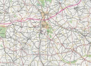
From Phenix City, AL, I-14 would use the existing US 80 Columbus/Phenix City northern bypass (known as J.R. Allen Parkway in Georgia), the northeasternmost part of the Columbus-Manchester Expressway (US 27 Alt/GA 85) into Harris County, then just south of Waverly Hall, it would proceed eastward, paralleling US 80/GA 22 all the way to I-75.
I-14 would cross I-75 just south of Hartley Bridge Road (I-75 Exit 155) in Bibb County, putting it between the downtown areas of Macon and Warner Robins.
From I-75, I-14 would proceed into Twiggs County, where it would cross I-16 and then go northeastward toward US 441 /GA 29, crossing it just south of Milledgeville and Baldwin State Forest.
Before reaching its final end at I-20 just east of US 221/GA 47 (I-20 Exit 183) in Columbia County, it would go north of the cities of Sandersville and Gibson, which are the county seats of Washington and Glascock Counties, respectively.
One advantage of having an I-14 would be to give central Alabama and central Georgia a high-speed way to get to and from Augusta and points eastward (Columbia, Florence, and Myrtle Beach, SC) without having to go through the Atlanta area, thus hopefully alleviating some of Atlanta's traffic woes. For example, to travel from Montgomery to Augusta via interstate, you would have to go I-85 to I-285 to I-20, putting you right smack-dab in a potential Atlanta gridlock situation.
Roughly, I estimate the distance of my proposed I-14 within Georgia to be 190 miles (304 km).
PLEASE NOTE: This is only the opinion of "The Georgia Road Geek" and does not represent in any way, shape, form or fashion, any official plans that the Georgia DOT may or may not have.
In the meantime, please feel free, my fellow road enthusiasts, to share your thoughts and ideas.
That's all for now. Thanks for visiting and please do so often.
Wednesday, November 16, 2005
I-75/I-575 Toll Lane Project (Update)
According to the Atlanta Journal-Constitution, yesterday (Tuesday), the Georgia DOT (GDOT) officially rolled out a new toll lane plan for the I-75 and I-575 corridors.
Please click here to read the full article.
As far as traffic congestion is concerned, GDOT has already built miles of high-occupancy vehicle (HOV) lanes on I-20, I-75, and I-85, but they don't seem to improve our traffic here one bit, and I don't seem to see where this new public-private proposal for I-75 and I-575 will help, either.
Most recently, GDOT hardened the shoulders on US 19/GA 400 from the North Springs MARTA Transit Station (Exit 5C) in Sandy Springs to Windward Parkway (Exit 11) in Alpharetta, all for MARTA and Xpress buses to use when traffic slows below 35 MPH. While this seems great for buses, it still doesn't seem to alleviate the congestion for the rest of us. IMHO, GDOT should have looked at the concept Germany designed and implemented on some of its Autobahns, where the shoulder is used as an auxiliary lane for all traffic during periods of major congestion, and should have redesigned the shoulders accordingly. (See the National Geographic Channel's "Megastructures" episode on the Autobahn.)
The root of the entire traffic problem here in "The A-T-L" is the out-of-control development, especially on the northside (Cobb, Cherokee, North Fulton, Gwinnett, and Forsyth Counties). Developers have been allowed to run amok, all with the implicit (if not explicit) blessings of our elected officials. As a result, they've been allowed to build way too many high-density subdivisions and industrial parks on roads that were once rural (i.e. Georgia Highway 9 in North Fulton and Forsyth Counties)... and we wonder why traffic here stinks!!!
Yes, I am for much-needed infrastructure improvements (roads, sewers, etc.). However, I am more for putting serious controls on development. While the Metro Atlanta area has become a more popular place for people fromall over the country, and other parts of the world, to live and work, there will eventually come a time when our infrastructure can no longer handle it and we even may stagnate and begin to lose people and jobs.
BTW, I am beginning to see the Charlotte/Mecklenburg County, North Carolina, Metro area grow just as we have down here, especially where sections of their new I-485 beltway have been opened. According to my wife's relatives in Charlotte, they are already seeing the signs of "another Atlanta" as developers are doing the same thing there. Being that our two major metro areas (Atlanta and Charlotte) are on I-85, with Greenville/Spartanburg, South Carolina, in the path and growing as well, it seems that this ungodly sprawl is becoming a "bubonic plague", the victims being both the residents and the infrastructures of northern Georgia and the Carolinas. In this case, it's spread by a new breed of "rats"... greedy developers!!!
That's enough "ranting and raving" for today. Thanks for visiting and please come back again.
Saturday, November 12, 2005
GA 400 - New Exit Ramp For GA 20
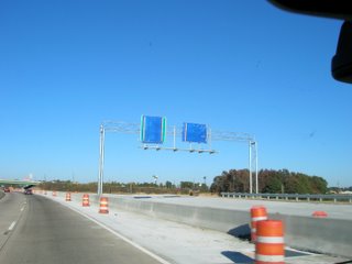
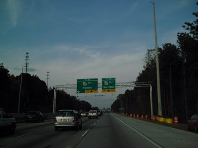
Hot off the digital camera, "The Georgia Road Geek" presents to you, fellow road enthusiasts, pictures of a new northbound exit ramp on US 19/GA 400 for Exit 14 (GA 20/Buford/Cumming).
Photo #1: Initial approach to the new overhead gantry that contains the new sign for Exit 14 and a new brown sign "Lake Lanier Islands - Exit 14". (NOTE: The old brown sign also referenced "Buford Dam", but the Georgia DOT decided not to do so on the new one).
Photo #1: Initial approach to the new overhead gantry that contains the new sign for Exit 14 and a new brown sign "Lake Lanier Islands - Exit 14". (NOTE: The old brown sign also referenced "Buford Dam", but the Georgia DOT decided not to do so on the new one).

Photo #2: The new Exit 14 gore sign can now be seen.

Photo #3: New overhead gantry on the ramp itself for GA 20 West (Cumming) and GA 20 East (Buford) signs.
The ramp will officially open on Tuesday, November 15th, to traffic, but for now, all GA 20 traffic will be routed under the bridge and looped over.
The next phase of the ramp construction is to complete a new GA 20 eastbound ramp. Once this is done, the loop will be for westbound GA 20 traffic only. At this time, we do not know when it will be completed, but once we find out, we'll let y'all know.
That's all for now. Thanks for visiting and please do so again.
Friday, November 11, 2005
Veterans Day
Today, I just wanted to take some time to wish everyone a happy Veterans Day.
Regardless of your personal and political views, please take some time to reflect on how much veterans have contributed to defending our country and if you can, tell ones you know (both veterans and current military personnel) how much you appreciate their service on our behalf.
My little brother Chris, a U.S. Naval Academy alum, proudly serves us and I appreciate his doing so. I am a graduate of North Georgia College (and State University) and several alumni, staff, and even current students who are in the National Guard and reserves, are currently serving in Afghanistan and Iraq.
Here in Georgia, we have honored veterans with various stretches of highways, including, but not limited to, sections of various state highways being designated by the Georgia General Assembly as Blue Star Memorial Highways and naming the eastern stretch of I-20 from I-285 in DeKalb County to the South Carolina state line as the Purple Heart Highway.
Again, regardless of your personal and political views, please take some time to reflect and, if you can, personally thank a veteran and/or any current service member you may know. Freedom isn't free and thousands have sacrificed both life and limb so that we can continue to be free.
That's all for now. Thanks for visiting and please come back again.
Wednesday, November 09, 2005
The New GA 400 Signs Are Here!!!
Fellow road enthusiasts, here is the official “Georgia Road Geek” debut of some of the brand new signage the Georgia DOT has recently placed along US 19/GA 400.
First, the new BGS gantry signs for Abernathy Road (Exits 5A-B) that replaced the old fiberglass ones:
First, the new BGS gantry signs for Abernathy Road (Exits 5A-B) that replaced the old fiberglass ones:

To see what the old ones looked like, please click here for the picture from the AARoads Georgia Gateway website.
Next, here’s a brand new BGS gantry for GA 140 (Exits 7A-B):
Here's one of the new large shield sets, this one located on the northbound side just past the Mansell Road exit (Exit 8):

Finally, as promised, here’s the infamous erroneous Roswell/Dahlonega distance sign as per my prior GA 400-related blogs:
Now that I’m thinking about it, perhaps GDOT is secretly trying to metricate us here in Georgia when they put “Roswell 9”, since 9 kilometers is approximately 5 miles. :)
To see what the old Roswell/Dahlonega distance sign looked like, please click here for the picture from AARoads Georgia Gateway website.
In other “Georgia Road Geek” news, here’s a picture I took while stuck in traffic on GA 9 (pre-1981 US 19) near the intersection of McFarland Road in Forsyth County:
This is indicative of the bottleneck that always occurs on this section of GA 9 during rush hour.
Forsyth County widened McFarland Road from 2 to 4-lanes divided with a grassy median from here to its other end at McGinnis Ferry Road (the Fulton/Forsyth County line). Both GA 9 and McGinnis Ferry are 2-lane roads which were never designed to carry near as much traffic as it does now. However, the Georgia DOT just recently redesigned the US 19/GA 400 interchange with McFarland (Exits 12A-B North, Exit 12 South). As soon as I can, I’ll get McFarland Road photos for y’all to see, but if you have any to share, then please e-mail it to steve#georgiaroadgeek.com and feature them in a future blog (with due credit to the photographer, of course).
That’s all for now. Thanks for visiting and please come back soon.
Monday, November 07, 2005
I-75/I-575 Toll Lane Project Proposal
According to today’s Atlanta-Journal Constitution (AJC), the Public-Private Initiative (PPI) to build special toll lanes on I-75 and I-575 in Cobb and Cherokee Counties, also known as the Northwest Corridor, is moving forward.
Please click here for the article from the AJC.
On Thursday, the Georgia DOT (GDOT) will hold a meeting to sketch out the latest proposal to create these special toll lanes on I-75.
Please click here for the official GDOT news release on the Northwest Corridor.
To learn more about other Georgia DOT PPIs, please visit the GDOT PPI Website.
That’s all for now. Thanks for visiting and please come back often.
Sunday, November 06, 2005
A Georgian Helped Build The Interstates
Next year (2006) will be the 50th anniversary of the Eisenhower Interstate System, launched by the Federal-Aid Highway Act of 1956.
“A Georgia native, General Lucius D. Clay of Marietta, is credited with being the principal architect of the system. In 1954 President Eisenhower appointed Clay, who had managed the Berlin Airlift and presided over the rebuilding of Germany after World War II, to chair a committee charged with mapping out a national interstate highway system. Clay's leadership brought Interstates 75, 85, and 20 through Atlanta, cementing the city's destiny as a transportation hub.” [1]
The interstates as we know them were inspired by Germany’s autobahns, originally built during Adolf Hitler’s 12-year reign over Germany.
After World War II, Eisenhower was so impressed by these autobahns, he began to think about a similar system for the U.S. When he was elected President in 1952, he was able to take his dream and work toward making it a reality with the help of General Clay.
Today, because of their visions, we have the world’s largest network of national superhighways totaling “46,726 miles as of 2003” [1] (approximately 74,762 km). Germany, the birthplace of the modern superhighway, ranks a distant second with a total of “11,712 km in 2001” [2] (approximately 7292 miles).
To learn more about Georgia’s interstates and Germany’s autobahns, please click on the hyperlinks for each of the footnotes below:
1 - John D. Toon, Georgia Institute of Technology, “The New Georgia Encyclopedia – Transportation – Interstate Highway System”, 2004.
2 – Brian K. Purcell, “The Texas Highwayman: Driving In Germany – The Autobahn”, 2002.
That’s all for now. Thanks for visiting and please come back soon.
Friday, November 04, 2005
Speed, Cellphones, and GA 400
This morning, I came across a very interesting article regarding a plan to track traffic speeds andbottlenecks by "pinging" cellphones. Georgia DOT has contracted with a Marietta, Georgia, firm, AirSage, that will install special software in existing Sprint cell towers for this particular purpose.
For now, it will be done on a stretch of I-75 between the southside of I-285 near the Airport to Macon.
Please click here for the full article from the Atlanta-Journal Constitution.
As for other Georgia Road Geek news, there have been some more BGS replacements on US 19/GA 400 as follows:
- All "button copy" signs have now been dismantled (except the northbound BGS for Exit 5A/Abernathy Road/Dunwoody/Sandy Springs/Next Right).
- New reflective signs have been placed from Abernathy Road (Exit 5 South/Exits 5A-B North) to I-285.
- A new overhead gantry has been placed on the northbound side between the Chattahoochee River and GA 140 (Exits 7A-B, Holcomb Bridge Road).
- New pole-mounted reflective signs on the southbound lanes for GA 140/Holcomb Bridge Road/Roswell at the 1/2-mile point and the exit itself.
- New pole-mounted reflective signs at Mansell Road (Exit 8), one northbound at the 1/2-mile point, the other southbound at the exit itself.
BTW, GDOT has yet to correct their mileage sign error, where they replaced the "Roswell 5/Dahlonega 43" sign with "Roswell 9/Dahlonega 26". I hope to get a picture of this sign soon, but if you do, then please e-mail it to me (steve#georgiaroadgeek.com). I'll post it on the blogsite and give the photographer due credit.
Lastly, here's a special "shout-out" to fellow road enthusiast Pete Jenior for his upcoming completion of a Transportation Engineering degree from Georgia Tech. Pete's got a nice website with "roadgeek meet" pages and excellent historical info on Atlanta's transportation planning throught the last 60-70 years. Please click here to see Pete's Road Site.
That's all for today. Thanks again for visiting and please do so often.
Subscribe to:
Posts (Atom)
