Well, dear reader, that darned webpage-creatin' frenzy just struck me again!!! :)
For your viewing pleasure, I have just created and published the final special feature page for our most recent I-85 northbound trip in Georgia. Please click here to see it.
For a special bonus toe-tappin' "roadgeek treat" (a 20-second Quicktime movie), then please click here.
That'll be it for now... unless that frenzy strikes me again tonight. Thanks for visiting, hope you enjoy my work, and please come back again.
Thursday, August 31, 2006

I-85 NB Scenes In GA - August 19, 2006 (Pt. 1)
Well, dear reader, I've just created and published yet another special feature page.
This is the first in a series of I-85 northbound pictures that I took as the wife and I headed toward Virginia and DC, and there will be more to come. Please click here to see them.
That's it for today. Hope y'all enjoy them, thanks for visiting, and please come back again.
This is the first in a series of I-85 northbound pictures that I took as the wife and I headed toward Virginia and DC, and there will be more to come. Please click here to see them.
That's it for today. Hope y'all enjoy them, thanks for visiting, and please come back again.
Wednesday, August 30, 2006
Virginia Roads And A GA 400 Update
First of all, regarding my last blog...
Michael Roberson (a.k.a. "Mapmikey"), co-curator of the Virginia Highways Project website, posted the following comment on both the Southeast Roads Yahoo! Group (seroads) and misc.transport.road...
There are numerous state-maintained routes in Virginia shorter than this.
Primary: VA 54Y is 0.03 mi
VA 201Y is 0.11 mi
VA 300Y is 0.04 mi
other Y routes that are now gone were shorter than that (208Y, 340Y)
VA 124 is 0.17 mi gone now but VA 289 was 0.13 mi (Wythe County)
VA 332 is 0.14 mi
VA 335 is 0.18 mi
VA 342 is 0.16 mi
VA 349 is 0.12 mi
VA 363 is 0.14 mi
VA 374 is 0.14 mi
VA 390 is 0.13 mi
VA 391 is 0.17 mi
VA 399 is 0.11 mi
The list of secondary routes less than this is astronomical but F-338 on VA 30 at I-95 is listed officially at 0.03 mi but the end state maintenance sign appears to be much closer to VA 30 than 150 ft.
A very special thanks to "Mapmikey" for the clarification and we here at "The Georgia Road Geek" encourage you, dear reader, to visit his website to learn more about Virginia's roads. :)
And finally, some new Georgia road news regarding GA 400...
According to an article published on Sunday, August 13, 2006, in the Forsyth County News, Georgia State Transpotation Board Chairman Mike Evans stated that the US 19/GA 400 widening between HolcombBridge Road (Exit 7) and Windward Parkway (Exit 11) should be complete by October 31, 2006, and the portion from Windward to McFarland Parkway (Exit 12) will be completed by February 28, 2007.
That's all for now. Thanks for visiting and please do so often.
Michael Roberson (a.k.a. "Mapmikey"), co-curator of the Virginia Highways Project website, posted the following comment on both the Southeast Roads Yahoo! Group (seroads) and misc.transport.road...
There are numerous state-maintained routes in Virginia shorter than this.
Primary: VA 54Y is 0.03 mi
VA 201Y is 0.11 mi
VA 300Y is 0.04 mi
other Y routes that are now gone were shorter than that (208Y, 340Y)
VA 124 is 0.17 mi gone now but VA 289 was 0.13 mi (Wythe County)
VA 332 is 0.14 mi
VA 335 is 0.18 mi
VA 342 is 0.16 mi
VA 349 is 0.12 mi
VA 363 is 0.14 mi
VA 374 is 0.14 mi
VA 390 is 0.13 mi
VA 391 is 0.17 mi
VA 399 is 0.11 mi
The list of secondary routes less than this is astronomical but F-338 on VA 30 at I-95 is listed officially at 0.03 mi but the end state maintenance sign appears to be much closer to VA 30 than 150 ft.
A very special thanks to "Mapmikey" for the clarification and we here at "The Georgia Road Geek" encourage you, dear reader, to visit his website to learn more about Virginia's roads. :)
And finally, some new Georgia road news regarding GA 400...
According to an article published on Sunday, August 13, 2006, in the Forsyth County News, Georgia State Transpotation Board Chairman Mike Evans stated that the US 19/GA 400 widening between HolcombBridge Road (Exit 7) and Windward Parkway (Exit 11) should be complete by October 31, 2006, and the portion from Windward to McFarland Parkway (Exit 12) will be completed by February 28, 2007.
That's all for now. Thanks for visiting and please do so often.
Tuesday, August 29, 2006
The Shortest State Highway In America?
Dear reader, I have been on a webpage-creatin' frenzy since getting back from Washington. :)
At 0.18 miles, VA Secondary Route 1015 in Fluvanna County, VA, seems to be the shortest state highway in America? Please click here for the special feature page I created.
If there are any state-maintained routes that are shorter, I'd like to know. Please feel free to share your thoughts.
That's all for now, but considering the roll I've been on, you never, ever know. :)
Thanks for visiting and please do so often.
At 0.18 miles, VA Secondary Route 1015 in Fluvanna County, VA, seems to be the shortest state highway in America? Please click here for the special feature page I created.
If there are any state-maintained routes that are shorter, I'd like to know. Please feel free to share your thoughts.
That's all for now, but considering the roll I've been on, you never, ever know. :)
Thanks for visiting and please do so often.
Welcome Center Photos - August, 2006
Dear Reader,
Just a quick post before I go do some household chores...
As part of the ongoing Special Features Pages series, I have added yet another page with photos from the North Carolina, South Carolina, and Virginia welcome centers. Please click here to see the new page.
Well, it's time to get the "recyclables" taken care of. Thanks for visiting and please come back again.
Just a quick post before I go do some household chores...
As part of the ongoing Special Features Pages series, I have added yet another page with photos from the North Carolina, South Carolina, and Virginia welcome centers. Please click here to see the new page.
Well, it's time to get the "recyclables" taken care of. Thanks for visiting and please come back again.
Monday, August 28, 2006
NEW: Special Feature Pages
New to "The Georgia Road Geek"... Special Feature Pages!!!
Whenever I do a blog and create a special feature page to go along with it, that page's URL will be linked from the Special Feature Pages section. For example, the "Old US 41 (Dixie Highway) in Adairsville" page is now available through this particular archive site.
A special thanks to fellow road enthusiast Adam Prince of Gribble Nation for suggesting this.
Finally, for a really, really special "roadgeek treat"..... please click here.
That's all for now. Thanks for visiting, please tell all your friends about us, and please visit often.
Whenever I do a blog and create a special feature page to go along with it, that page's URL will be linked from the Special Feature Pages section. For example, the "Old US 41 (Dixie Highway) in Adairsville" page is now available through this particular archive site.
A special thanks to fellow road enthusiast Adam Prince of Gribble Nation for suggesting this.
Finally, for a really, really special "roadgeek treat"..... please click here.
That's all for now. Thanks for visiting, please tell all your friends about us, and please visit often.
Sunday, August 27, 2006
Our DC, Maryland, and Virginia Trip
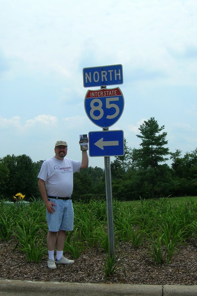
Steve at NC Welcome Center on I-85 NB (Photo taken by Mary Williams)
Today (Sunday, 8/27) at approximately 2:45 PM, just south of Greensboro, NC... I have now driven every mile of I-85 from Montgomery, AL, to Petersburg, VA!!! :)
Mary and I spent the last week in the Washington, DC, metro area. Other than "roadgeeking", we got to tour The White House, The Capitol, the Holocaust Museum, Arlington Cemetery, and the Smithsonian Air and Space and American History museums. We also visited Mount Vernon, saw Mary's old house in Chantilly (just south of the Dulles Airport), and did a lot of scenic driving and "roadgeeking". We also attended part of the Toastmasters International convention at the Hilton Washington. We actually stayed in Alexandria, VA, and took the DC Metro train for most of our DC visits. Kudos to the Metro for being convenient to most of the sites we visited.
Before reaching DC, we headed up US 29 to Charlottesville, VA, to visit Thomas Jefferson's Monticello and spend the night with her old friend Katherine. Thanks to Katherine, her husband Larry, and her mother Bunny for a wonderful time, plus a suggested scenic drive between Charlottesville and Fredericksburg that we took on our way to the DC area.
Besides clinching I-85, I also clinched I-295 in DC/Maryland, did some driving on I-64, I-66, I-81, I-395, I-495, and of course I-95 between I-85 and I-295 in Maryland. In addition to adding some new interstate driving mileage, I also added boatloads of new counties in DC, MD, NC, and VA, and even drove over the new Woodrow Wilson Bridge.
I took over 400 photos, and even Mary took several while we were on I-495 between Connecticut Avenue in Maryland to I-95/395 in Alexandria. Eventually, I'll go through them and share the best ones with y'all.
That's all for now. It's getting late, we've only been home since 8:30 PM, and I'm tired after nearly 12 hours on the road. Mary went to bed over an hour ago and I'm gonna join her.
Thanks for visiting and please come back again.
Saturday, August 12, 2006
The Old Dixie Highway In Adairsville
Last weekend, Mary and I went back to Subligna for her father's annual family reunion and Subligna Methodist Church homecoming.
On the way back home Sunday, we briefly stopped in Adairsville to get a photo of a Dixie Highway sign that we'd seen on GA 140 for the longest time. Since the sign on GA 140 was not in a good spot for a photo, we pulled off the road onto a street that turned out to be part of the old US 41... The Dixie Highway itself!!! :)
For your viewing pleasure, I have created a new page featuring the photos we took.
Next Saturday, we're heading to Washington, DC, and northern Virginia to see the sights and attend the Toastmasters convention. Since I'll be driving us up there and back, I'll be "clinching" a ton of new counties in Virginia, North Carolina, West Virginia (for Harper's Ferry), and hopefully at least one or two in Maryland. Oh yeah... by the time we get back, we will have "clinched" all of I-85!!! :)
That's all for now. Thanks for reading, hope you enjoy the photos, and please visit often.
On the way back home Sunday, we briefly stopped in Adairsville to get a photo of a Dixie Highway sign that we'd seen on GA 140 for the longest time. Since the sign on GA 140 was not in a good spot for a photo, we pulled off the road onto a street that turned out to be part of the old US 41... The Dixie Highway itself!!! :)
For your viewing pleasure, I have created a new page featuring the photos we took.
Next Saturday, we're heading to Washington, DC, and northern Virginia to see the sights and attend the Toastmasters convention. Since I'll be driving us up there and back, I'll be "clinching" a ton of new counties in Virginia, North Carolina, West Virginia (for Harper's Ferry), and hopefully at least one or two in Maryland. Oh yeah... by the time we get back, we will have "clinched" all of I-85!!! :)
That's all for now. Thanks for reading, hope you enjoy the photos, and please visit often.
Thursday, August 03, 2006
The GA 400 Survival Kit
This afternoon as I was making my way toward home, the traffic on both I-285 outer loop and GA 400 northbound was horrendous... even more than usual!!!
Thankfully, I had my ham radio rig in the truck and QSOing (talking) with fellow hams David, Hutch, Marshall, and James on the Atlanta Radio Club's (ARC) 146.82 MHz repeater really helped make the ride a little more bearable.
During my QSO with David, he mentioned that he avoids GA 400 whenever possible and I can't blame him for doing so. He even (jokingly) had the idea of a "GA 400 survival kit" that would include provisions (food, water, etc.) for all those long times one spends in traffic on that infamous Metro Atlanta road.
While I may not literally pack provisions, I am thankful for my own "survival kit", my ham radio rig... and for all the hams I talk to on both the ARC repeater and the Sawnee Mountain Amateur Group's 147.15 MHz repeater. You guys are great!!! :)
That's all for now. I'm getting ready for tomorrow and I'll be going to bed soon.
Thanks, dear reader, for visiting, reading, and for all your support.
Thankfully, I had my ham radio rig in the truck and QSOing (talking) with fellow hams David, Hutch, Marshall, and James on the Atlanta Radio Club's (ARC) 146.82 MHz repeater really helped make the ride a little more bearable.
During my QSO with David, he mentioned that he avoids GA 400 whenever possible and I can't blame him for doing so. He even (jokingly) had the idea of a "GA 400 survival kit" that would include provisions (food, water, etc.) for all those long times one spends in traffic on that infamous Metro Atlanta road.
While I may not literally pack provisions, I am thankful for my own "survival kit", my ham radio rig... and for all the hams I talk to on both the ARC repeater and the Sawnee Mountain Amateur Group's 147.15 MHz repeater. You guys are great!!! :)
That's all for now. I'm getting ready for tomorrow and I'll be going to bed soon.
Thanks, dear reader, for visiting, reading, and for all your support.
Monday, July 31, 2006
The Videos Are Back
Since we now have boatloads of webserver space, we've uploaded our small collection of self-produced "roadgeek videos" for your viewing pleasure. Please click here for the video page.
That's all for tonight. Thanks for visiting and please come back often.
That's all for tonight. Thanks for visiting and please come back often.
Sunday, July 30, 2006
Website Changes
Dear Reader,
For future expansion of "The Georgia Road Geek", we have moved the non-blog website contents to our new web hosting service "Go Daddy".
As you may have noticed on the main page, we have made some website design changes, including a new main menu and a consolidated links page.
Thanks to "Go Daddy", we even have our own georgiaroadgeek.com e-mail accounts and have made it easier for you, the reader, to contact us. To e-mail us, please go to the main menu.
It's getting to be time for our afternoon "Sunday Siesta", so that's all for now. Thanks for reading and we hope you enjoy the new look and feel of "The Georgia Road Geek".
For future expansion of "The Georgia Road Geek", we have moved the non-blog website contents to our new web hosting service "Go Daddy".
As you may have noticed on the main page, we have made some website design changes, including a new main menu and a consolidated links page.
Thanks to "Go Daddy", we even have our own georgiaroadgeek.com e-mail accounts and have made it easier for you, the reader, to contact us. To e-mail us, please go to the main menu.
It's getting to be time for our afternoon "Sunday Siesta", so that's all for now. Thanks for reading and we hope you enjoy the new look and feel of "The Georgia Road Geek".
Friday, July 28, 2006
We Got A Response
Regarding the name change from "McFarland Road" to "McFarland Parkway", here's the response we received from the Forsyth County Roads and Bridges Department:
Mr. Williams,
On April 20, 2006 the Forsyth County Board of Commissioners re-named McFarland Road to McFarland Parkway. The Georgia Department of Transportation has modified the exist signs on SR 400, at the ramps, and at SR 9.
We will be changing out all the overhead signs along McFarland Road at the signalized locations.
Please let me know if you need any additional information from me regarding this change.
Tim Allen
Assistant Director of Engineering
My e-mail was sent to Mr. Douglas Armstrong, who promptly forwarded the inquiry to Mr. Allen. "The Georgia Road Geek" kindly thanks both these gentlemen for their timely response.
That's all for now. Thanks for reading and have a great weekend!
Mr. Williams,
On April 20, 2006 the Forsyth County Board of Commissioners re-named McFarland Road to McFarland Parkway. The Georgia Department of Transportation has modified the exist signs on SR 400, at the ramps, and at SR 9.
We will be changing out all the overhead signs along McFarland Road at the signalized locations.
Please let me know if you need any additional information from me regarding this change.
Tim Allen
Assistant Director of Engineering
My e-mail was sent to Mr. Douglas Armstrong, who promptly forwarded the inquiry to Mr. Allen. "The Georgia Road Geek" kindly thanks both these gentlemen for their timely response.
That's all for now. Thanks for reading and have a great weekend!
Wednesday, July 26, 2006
What's Up With That?
Today, as I made my way north up GA 400, I noticed that the Georgia DOT has replaced BGSes (that's "Big Green Signs") for McFarland Road (Exit 12 South/12A-B North) with new ones that say "McFarland Pkwy".
Forsyth County, who maintains this particular road, has not changed street signs... at least not yet.
Being "The Georgia Road Geek", my inquiring mind wants to know what's up with that, so I sent an e-mail to the Forsyth County Roads and Bridges Department. As soon as I get an answer, I'll share it with y'all.
In any event, this looks like yet another "roadgeek photo op", so I'll get a picture taken and post it for your viewing pleasure ASAP.
Has anyone else out there read the latest Atlanta Journal-Constitution (AJC) article regarding future roads and road improvements and the ideas of putting tolls on them? What's up with that? Click here to read it for yourself and please feel free to share your comments with us.
As I've said in past blogs, we have brought much of this mess upon ourselves by allowing development to get out-of-hand... and the politicians want us literally to pay to fix it with public-private initiative projects (PPIs) that will slap tolls on all newly constructed roads and newer lanes parallelling segments of existing roads. To our politicans, I say let's get a handle on the out-of-control growth first and foremost instead of just throwing money at projects that, at best, will be nothing but temporary "band-aids". Here's another AJC article listing the current PPIs proposed for Georgia.
That's all for now. Thanks for reading and please do so often.
Forsyth County, who maintains this particular road, has not changed street signs... at least not yet.
Being "The Georgia Road Geek", my inquiring mind wants to know what's up with that, so I sent an e-mail to the Forsyth County Roads and Bridges Department. As soon as I get an answer, I'll share it with y'all.
In any event, this looks like yet another "roadgeek photo op", so I'll get a picture taken and post it for your viewing pleasure ASAP.
Has anyone else out there read the latest Atlanta Journal-Constitution (AJC) article regarding future roads and road improvements and the ideas of putting tolls on them? What's up with that? Click here to read it for yourself and please feel free to share your comments with us.
As I've said in past blogs, we have brought much of this mess upon ourselves by allowing development to get out-of-hand... and the politicians want us literally to pay to fix it with public-private initiative projects (PPIs) that will slap tolls on all newly constructed roads and newer lanes parallelling segments of existing roads. To our politicans, I say let's get a handle on the out-of-control growth first and foremost instead of just throwing money at projects that, at best, will be nothing but temporary "band-aids". Here's another AJC article listing the current PPIs proposed for Georgia.
That's all for now. Thanks for reading and please do so often.
Thursday, July 20, 2006
Our 15 Minutes Of Fame
The late Andy Warhol once said that everyone will get their "15 minutes of fame"... and we just got ours, thanks to the Roswell Neighbor.
Please click here to read the article written by Joan Durbin.
One minor point of clarification... I am 42, not 55. :)
Hope y'all enjoyed it, thanks for visiting and your support, and please visit often.
Please click here to read the article written by Joan Durbin.
One minor point of clarification... I am 42, not 55. :)
Hope y'all enjoyed it, thanks for visiting and your support, and please visit often.
Friday, July 14, 2006
My News Interview
A couple of weeks ago, the Roswell Neighbor newspaper ran a solicitation asking people about their commutes on GA 400 and what they do in their vehicle during such times.
Since I drive up and down GA 400 to and from work, I sent them an e-mail talking about my ham radio and roadgeeking... and they wanted to hear more!!! :)
Last Wednesday, I had a noon phone interview Joan Durbin. We had a real nice chat about what ham radio is, what we talk about on the ham radio, and last, but not least, my roadgeeking and what it's all about. During our interview, Joan was browsing this blogsite plus my "clinched" Interstate page. She was very fascinated as to why I was a self-proclaimed "roadgeek" and what led me to become such.
At 4:30 PM that same day, I met up with Skip, one of their photographers, at the Mansell MARTA Park and Ride lot off Exit 8 (Mansell Road), and he rode with me up GA 400 to Exit 10 (GA 120/Old Milton Parkway) and back, taking tons of pictures of me talking on my 2m VHF ham radio and the traffic jam in front of me. Before I dropped Skip off back at the Mansell lot, I gave him my e-mail address so that he could send me the photo(s) that they will use in the Roswell Neighbor.
As soon as the article comes out, I'll let y'all know.
Many thanks to Joan and Skip for their interest and time, my fellow ham radio operators for our QSOs (conversations) while Skip took pictures, and finally, thanks to you for reading and supporting "The Georgia Road Geek".
That's all for now. Have a great weekend!!!
Since I drive up and down GA 400 to and from work, I sent them an e-mail talking about my ham radio and roadgeeking... and they wanted to hear more!!! :)
Last Wednesday, I had a noon phone interview Joan Durbin. We had a real nice chat about what ham radio is, what we talk about on the ham radio, and last, but not least, my roadgeeking and what it's all about. During our interview, Joan was browsing this blogsite plus my "clinched" Interstate page. She was very fascinated as to why I was a self-proclaimed "roadgeek" and what led me to become such.
At 4:30 PM that same day, I met up with Skip, one of their photographers, at the Mansell MARTA Park and Ride lot off Exit 8 (Mansell Road), and he rode with me up GA 400 to Exit 10 (GA 120/Old Milton Parkway) and back, taking tons of pictures of me talking on my 2m VHF ham radio and the traffic jam in front of me. Before I dropped Skip off back at the Mansell lot, I gave him my e-mail address so that he could send me the photo(s) that they will use in the Roswell Neighbor.
As soon as the article comes out, I'll let y'all know.
Many thanks to Joan and Skip for their interest and time, my fellow ham radio operators for our QSOs (conversations) while Skip took pictures, and finally, thanks to you for reading and supporting "The Georgia Road Geek".
That's all for now. Have a great weekend!!!
Saturday, July 08, 2006
Pine Log Diversion
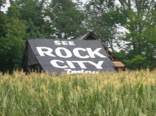
Last Monday, on our way back home from Subligna, Mary spotted a "See Rock City" barn on US 411/GA 61 just yards north of GA 140. She wanted to snap a picture of it and I happily obliged her. :) Here's the photo...
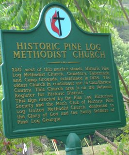
Just after snapping the pic, we ventured a little further north on US 411 and wound up turning at the tunnel bridge. There we spotted a green historical marker for the Pine Log United Methodist Church, so we went under the bridge to see the church. Here's a picture of the marker itself...
Not only did we see the church (a beautiful one at that), but we also got a look at the bridge, which is featured in J.T. Legg's Peach State Roads website. Here's our own photo of it...
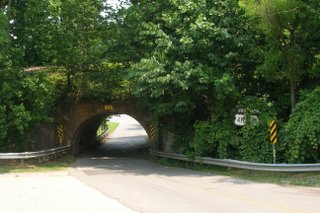
Here's also a closeup of the old "JUNCTION US 411/GA 61" sign...
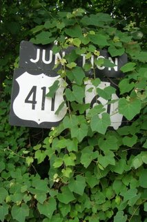
My wife wanted to move the kudzu, but I asked her to leave it "as is" for a somewhat "artistic" purpose. In today's vernacular, I wanted her to "keep it real". :)
For J.T. Legg's pictures and his perspective, please click here.
I'm glad my wife wanted to get a picture of the "See Rock City" barn. It also goes to show that when you venture off the beaten path sometimes, you never know what you'll encounter. Besides that and the old historic church, it was really neat to see the old tunnel bridge that I've only seen on J.T.'s website. In the end, I got a little history... and a little unexpected "extra roadgeeking" done.
That's all for now. Thanks for visiting and please do so often.
Monday, July 03, 2006
Mary's Scenic Byway

Yesterday (Sunday, 7/2/2006), my wife and I did a three-hour jaunt from Subligna and back as follows...
- Gore-Subligna Road to US 27/GA 1.
- US 27/GA 1 to GA 48 in Summerville.
- GA 48/AL 117 to I-59 (Exit 231) in Hammondville, AL.
- I-59 to GA 136 (Exit 11) in Trenton.
- GA 136 to East Armuchee Road.
- East Armuchee Road to Gore-Subligna Road.
Our first stop was in Summerville to see the railroad turntable that was installed in 2003 thanks to some federal transportation funding that almost did not happen due to the 9/11 attacks. Here's a photo we took...

After visiting the turntable, we proceeded west on GA 48 toward Alabama. This was the first of many scenic portions that we encountered, as GA 48 meandered its way over Lookout Mountain and on into Alabama, where it becomes AL 117.
Along AL 117 between the Georgia Line and I-59, we noticed that almost every road (including several dirt roads) were signed with blue pentagon county route markers. Here's an example (please pardon the photo quality)...
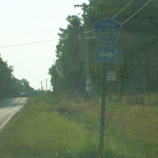
There were even some blue county route markers that contained the number but not the county name.
The next scenic view on AL 117 was found between Mentone and Valley Hill.
After stopping for gas in Valley Hill, we made our way to I-59, which we took from AL 117 (Exit 231) to GA 136 (Exit 11) in Trenton. At that point in our journey, we had "clinched" 2 new counties... DeKalb County, Alabama, and Dade County, Georgia!!! Here's the scene as we approached the Georgia state line on I-59...
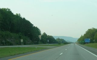
Initially, I was planning to "clinch" all of I-59 in GA up to its end at I-24 and make my way eastward toward Chattanooga, but my wife suggested taking GA 136 (a.k.a. "Lookout Mountain Parkway") instead. Initially, I was relunctant, but I'm glad that I did so.... because the drive on GA 136 around Lookout Mountain from Dade into Walker County was really awesome with its breathtaking scenery and the "hairpin curves". IMHO, this is the best stretch of mountain road we've ever been on since driving the Russell-Brasstown Scenic Byway.
Back to the subject of county routes, we noticed that, in Dade County, the street signs all tended to have the Dade County route number along with the street or road name. In Georgia, county route numbers are marked with long green signs behind the "STOP" sign (if they are even marked at all), but I found Dade County's system somewhat interesting.
We finally left GA 136 at its 4-way intersection with GA 201 and East Armuchee Road (part of the Ridge and Valley Scenic Byway). In just under 3 hours time, we finally made it back to Subligna.
The only part of the drive that we were not fond of were the extremely narrow bridges we crossed along AL 117, but it looked like Alabama DOT was grading out land and getting ready to replace one of them in the Mentone/Valley Hill vicinity.
Overall, we considered this to be a very good scenic trip and highly recommend it for anyone interested in both scenery and roads.
In honor of my lovely wife, I, "The Georgia Road Geek", do hereby designate this entire route as "Mary's Scenic Byway"!!! :)
That's all for now. Thanks for reading and please come back again.
Saturday, July 01, 2006
Belated Birthday Greetings
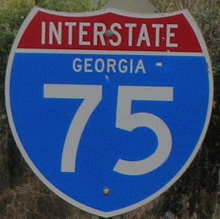
Dear readers, I was amiss in not posting a "Happy 50th Birthday" message yesterday to the Dwight D. Eisenhower Interstate System, so here goes....
Happy Birthday To You
Happy Birthday To You
Happy 50th Birthday Dwight D. Eisenhower Interstate System...
Happy Birthday To Yooooooooou.
... and many moooooore!!! :)
Last week, I had contemplated the idea of getting a birthday cake made for this occasion, but I did not follow through with it. If you did, or know of anyone else (besides state DOTs), then please let us know.
May y'all have a wonderful, happy, and safe 4th of July weekend.
Monday, June 26, 2006
4 Days And Counting!!!
As I write this blog, it is 4 more days until that great day in "roadgeekdom"... the Interstate Highway System's 50th Birthday!!!
Yesterday, the Georgia DOT began celebrations with a vintage car ride down I-75 from Windy Hill Road in Cobb County to The Varsity in Downtown Atlanta. To read more about this event, please click here for the article from the Atlanta Journal-Constitution.
At this very moment, a transcontinental convoy from San Francisco is travelling to Washington in commemoration of Dwight D. Eisenhower's 1919 military convoy, an event that helped shape the idea in his mind of a federal superhighway system. Thanks to modern-day GPS technology, you can see where the convoy is currently located courtesy of AASHTO. Click here for updates.
National City Network features webcasts of the historic convoy. Click here to see for yourself (NOTE: DSL or better connections work best.)
The public radio program "Living On Earth" recently interviewed Interstate expert and author Dan McNichol as he traveled down I-90. Please click here for a transcript and audio.
Yes, folks, the "Big 5-0" is approaching quick and we, your friends at "The Georgia Road Geek", encourage you to take a moment of your time to reflect on how the Interstate Highway System has affected your life and your travels down both the literal highways and the proverbial "highway of life".
Finally, I'd like to give a special "thank you" to my dad, for letting me be his "navigator". When I was a child, he would hand me the maps and I would help him get to one of our many vacation destinations. This helped give me an appreciation of America's various and sundry roads and highways. I guess I was a "roadgeek" before I found out what one was. :)
That's all for now. Thanks for reading and please come back again.
Yesterday, the Georgia DOT began celebrations with a vintage car ride down I-75 from Windy Hill Road in Cobb County to The Varsity in Downtown Atlanta. To read more about this event, please click here for the article from the Atlanta Journal-Constitution.
At this very moment, a transcontinental convoy from San Francisco is travelling to Washington in commemoration of Dwight D. Eisenhower's 1919 military convoy, an event that helped shape the idea in his mind of a federal superhighway system. Thanks to modern-day GPS technology, you can see where the convoy is currently located courtesy of AASHTO. Click here for updates.
National City Network features webcasts of the historic convoy. Click here to see for yourself (NOTE: DSL or better connections work best.)
The public radio program "Living On Earth" recently interviewed Interstate expert and author Dan McNichol as he traveled down I-90. Please click here for a transcript and audio.
Yes, folks, the "Big 5-0" is approaching quick and we, your friends at "The Georgia Road Geek", encourage you to take a moment of your time to reflect on how the Interstate Highway System has affected your life and your travels down both the literal highways and the proverbial "highway of life".
Finally, I'd like to give a special "thank you" to my dad, for letting me be his "navigator". When I was a child, he would hand me the maps and I would help him get to one of our many vacation destinations. This helped give me an appreciation of America's various and sundry roads and highways. I guess I was a "roadgeek" before I found out what one was. :)
That's all for now. Thanks for reading and please come back again.
Saturday, June 24, 2006
New GDOT Large Print Roadmaps
Fellow Road Enthusiasts,
According to a press release dated June 22, 2006, the Georgia DOT (GDOT) now has a "large print" state map which is being released to the state's welcome centers via the Georgia Department of Economic Development.
However, according to GDOT, you can get a "limited first edition" of this new map by contacting them directly. Their Map Sales unit e-mail address is OTDCustomerSrv@dot.state.ga.us.
Just before composing this blog, I e-mailed GDOT and put in a request. Once I receive the map, I'll look it over and give you my thoughts in a follow-up blog.
T0 read the full GDOT press release, please click here.
In other "Georgia Road Geek" news...
US 19/GA 400 construction in North Fulton and South Forsyth counties is really picking up the pace, with the median graded out and graveled/asphalted (and even some new "Jersey Barriers") between GA 14o/Holcomb Bridge Road (Exit 7) and GA 120/Old Milton Parkway (Exit 10), plus new northbound shoulder work being done between Windward Parkway (Exit 11) and McFarland Road (Exit 12). On the southbound lanes of GA 400 between McFarland and Windward, shoulder work has been completed. It has also been striped for temporary use as the rightmost lane during the ongoing widening process.
At the Haynes Bridge Road (Exit 9) acceleration ramp to GA 400 northbound, I've noticed several brand new BGSes that may be going up soon. They are currently sitting in racks, so I can't make out what they say.
In the meantime, contact GDOT for your "limited first edition" print map.
Finally, here's a "shout out" to my brother-in-law Lib for plugging my blog via his blog "The Smith Family Website". Thanks, Lib, for your kind words and support. I love you, man!!! :)
That's all for now. Thanks for visiting and please do so often.
According to a press release dated June 22, 2006, the Georgia DOT (GDOT) now has a "large print" state map which is being released to the state's welcome centers via the Georgia Department of Economic Development.
However, according to GDOT, you can get a "limited first edition" of this new map by contacting them directly. Their Map Sales unit e-mail address is OTDCustomerSrv@dot.state.ga.us.
Just before composing this blog, I e-mailed GDOT and put in a request. Once I receive the map, I'll look it over and give you my thoughts in a follow-up blog.
T0 read the full GDOT press release, please click here.
In other "Georgia Road Geek" news...
US 19/GA 400 construction in North Fulton and South Forsyth counties is really picking up the pace, with the median graded out and graveled/asphalted (and even some new "Jersey Barriers") between GA 14o/Holcomb Bridge Road (Exit 7) and GA 120/Old Milton Parkway (Exit 10), plus new northbound shoulder work being done between Windward Parkway (Exit 11) and McFarland Road (Exit 12). On the southbound lanes of GA 400 between McFarland and Windward, shoulder work has been completed. It has also been striped for temporary use as the rightmost lane during the ongoing widening process.
At the Haynes Bridge Road (Exit 9) acceleration ramp to GA 400 northbound, I've noticed several brand new BGSes that may be going up soon. They are currently sitting in racks, so I can't make out what they say.
In the meantime, contact GDOT for your "limited first edition" print map.
Finally, here's a "shout out" to my brother-in-law Lib for plugging my blog via his blog "The Smith Family Website". Thanks, Lib, for your kind words and support. I love you, man!!! :)
That's all for now. Thanks for visiting and please do so often.
Subscribe to:
Posts (Atom)
