Tuesday, January 31, 2006

Aerial Road Photo - Athens Perimeter NE Corner

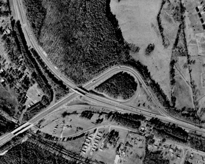
It's been awhile since I've posted any aerial photos of interchanges within Georgia, so I went to Terraserver-USA and got this shot of the northeastern corner of the Athens Perimeter (US 29/129/441/GA 15/10 Loop/422)...


Above photo from Terraserver-USA.

Many locals simply refer to the Athens Perimeter as "The 10 Loop".

The "half diamond" interchange in the bottom is Old Hull Road, which was originally US 29/GA 8 until the original northern section of the Athens Perimeter was completed in the 1960's.

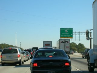
Northward is US 29/GA 8, going toward Danielsville. (Elberton is also a "control city", but the BGS doesn't tell you Elberton is accessible via GA 72, which ends at US 29/GA 8 just north of this interchange.)

Westward is US 129/441/GA 15/10 Loop/422, "control cities" being Commerce (US 441) and Jefferson (US 129). IMHO, Gainesville should be a control city as well, since Gainesville is a major city within Northeast Georgia and US 129 links both Athens and Gainesville.

Southward is US 29/129/441/GA 15/10 Loop/422, Control cities being Watkinsville and Madison. IMHO again, Lexington, Macon, and Augusta, should be "control cities" as well (or at least acknowledged when motorists approach US 78/GA 10 East (Lexington) and US 129/441/ GA 15 South (Macon/Augusta).

For more info on the Athens Perimeter, please visit both AARoads "Georgia Gateway" and Peach State Roads, both sites containing excellent road pics and historical details.

That's all for now. Thanks for visiting and please do so often.

Monday, January 30, 2006

Make Your Own Maps

I have just discovered the World66 website and their "Tools for Travelers".

From this website, I created the following maps...

First, here's a map of all the states I have visited throughout my lifetime...


Next, here's a map of all the states visited where I have operated a motor vehicle...


And finally, a map of the Canadian provinces I've visited...


On my next blog, I hope to officially debut my Clinched Interstates page.

Thanks for visiting and please do so often.

Thursday, January 26, 2006

A Roadgeek Test

How much of a roadgeek are you?

Here's a little gem I found on misc.transport.road... The Great American Highways Quiz.

To take this quiz, please click here.

I had taken the quiz and got 8 of 10 correct. The ones I missed were the total number of rest areas on the Interstates and the very first Interstate route.

As for Georgia road news, I found a very interesting article regarding the plans to change GA 9 through Alpharetta and how city leaders want to be involved in Georgia DOT's planning process. Please click here to read the article from the Atlanta Journal-Constitution.

I travel this stretch most days when I head home from work, and during rush hour, it gets extremely congested from Old Milton Parkway (GA 120) northward to Milton Avenue (at Alpharetta City Hall). Hopefully, GDOT and the City of Alpharetta can hammer out some kind of agreement for the benefit of both the traveling public and their downtown area... but we'll see. (I could go on another "too much development" tirade, but I've beaten that horse to death already.)

Hope you enjoyed both the test and the article, thanks for visiting, and please come again.

Wednesday, January 25, 2006

Toll Roads and Bridges

Today on the Southeast Roads Yahoo! Newsgroup, Alex "Roaddog" Nitzman shared information regarding a feasibility study by Georgia's State Road and Tollway Authority for a tollway in Savannah. Please click here for the article.

Before the GA 400 tollway was opened in 1993, there had been a "Toll US 80" highway in the eastern part of Savannah running between the downtown area and Savannah Beach (now Tybee Island). I believe that the toll on that particular road was discontinued sometime around the early 1980's at the latest. If you have any history regarding "Toll US 80", then please share it with us.

The other tolled facility in Georgia was the F.J. Torras Causeway (unsigned Glynn County Route 582), which runs from US 17/GA 25 in Brunswick to Saint Simons Island. The toll ($0.35) was only charged for vehicles heading into Saint Simons. On December 31, 2003, the toll was discontinued and all that was left was an empty shell of a toll plaza with a plain white "NO TOLL" sign on it. I wish I had taken a picture of it when we were there nearly 2 years ago. :(

From 1953 to 1975, the original Eugene Talmadge Memorial Bridge in Savannah was tolled. Fortunately, the current bridge, which Mary and I traveled across last October while in Savannah, was free from the day it was opened to traffic. While we crossed the bridge, I took a CVS video recorder and recorded our trips as we drove over the bridge from Georgia to South Carolina (and back). I need to get it developed into a DVD.

A special thanks to Alex for sharing this Savannah toll road proposal news with us here in the road enthusiast community.

BTW, has anyone ever thought of doing another "roads meet" in Georgia? If so, then please let me know.

That's all for now. Thanks for visiting and please come back again.

Sunday, January 22, 2006

Road Enthusiasts... They're Everywhere!!!

Tonight, I had received an e-mail from my second cousin Dana in Douglasville, GA, complimenting me on my blogsite.

In that same e-mail, she mentioned that her husband David, an apparent road enthusiast himself, told her how the interstates are laid out. Here's the text verbatim...

My husband, David was just telling me an hour ago (while looking at my NAV in the car) that all interstates that run North-South are odd #d and West-East are Even #d and they they graduate in #s from one end of the country to the other end. I had no idea!! LOL Sounds like y'all have alot in common.

Dana, like my wife Mary, is an avid scrapbooker. In fact, she has her own scrapbooking place called Camp Crop-A-Lot. If you're into scrapbooking (or at least know someone who is), check out Dana's website.

Speaking of scrapbooks, Mary and I have decided to combine my love of "roadgeeking" and her love of scrapbooking to eventually produce a "roadgeek scrapbook". As soon as it gets completed, we'll let y'all know.

Dana and David, thanks for visiting "The Georgia Road Geek" and for your kind words. :)

That's all for now, folks. Thanks for visiting and please do so often.

Friday, January 20, 2006

Controlled-Access Highways

On the newsgroup misc.transport.road, there was a discussion posted on how different states define expressways, freeways, and limited access.

I did a quick search of the Georgia Code and found the following:

'Controlled-access highway' means every highway, street, or roadway in respect to which owners or occupants of abutting lands and other persons have no legal right of access to or from the same except only at such points and in such manner as may be determined by the public authority having jurisdiction over such highway, street, or roadway. (Georgia Code 40-1-1(9))

On US 19/GA 400 just past its southernmost at-grade intersection (GA 369) and where I-575 becomes GA 515, there are actual green signs that denote the beginning and ending of access control. Please click here for an example (photo from the AARoads "Georgia Gateway" website).

There used to be "END LIMITED ACCESS" signs on US 78/GA 10 where the Stone Mountain Freeway ends in Gwinnett County, plus "END ACCESS CONTROL" signs on GA 316 and where I-985 becomes simply US 23/GA 365. On US 29/GA 8 just north of the northeastern quadrant of the Athens Perimeter, there was once an "END OF LIMITED ACCESS" sign.

The more common sign you will find at points where access control ends are yellow diamond warning signs saying "VEHICLES ENTERING AND CROSSING HIGHWAY".

If I could change this particular aspect of Georgia's highways, I would put simple yellow "END FREEWAY" warning signs like the ones I encountered while driving in southern California.

BTW, thanks to everyone who posted comments regarding "Roadgeeking... A Family Affair". It's nice to know that others care to involve their families, friends, and associates. The most recent example is from Alex "Roaddog" Nitzman, who has begun to indoctrinate his son into the roads hobby. We here at "The Georgia Road Geek" can't wait for his son's very first photo. :)

That's all for now. Thanks for visiting and please do so often.

Monday, January 16, 2006

Georgia's Covered Bridges

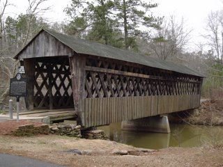
Today, I visited the Poole's Mill Bridge, a 1901 covered bridge near the Ducktown community of Forsyth County, Georgia. Here's the picture I took...

This is one of a mere handful of such structures that still exist throughout Georgia, and thank goodness that they are being preserved to give future generations a glimpse of the early pioneer roads and paths that linked people and places... way before the modern superhighways that we enjoy today.

The bridge is in Poole's Mill Park, owned and operated by the Forsyth County Parks and Recreation Department. (NOTE: The park's restrooms are closed for the winter. Otherwise, you may visit the park until sundown.)

These two road enthusiast sites also feature pictures of Georgia's covered bridges:

- Gribble Nation's Georgia Road Photos (Adam Prince)

- Peach State Roads Atlanta Northwest Photos (J.T. Legg)

The Georgia DOT also maintains a historic covered bridge website. (That's how I found out about the Poole's Mill Bridge, BTW.)

Kudos to Adam and J.T. for their respective websites and the hard work they put into them.

If you ever get a chance, visit a covered bridge near you. Whether or not you are a road enthusiast, I guarantee that you will appreciate the experience. I know I do.

That's all for now. Thanks for visiting and please do so often.
Friday, January 13, 2006

Roadgeeking... A Family Affair

Fellow road enthusiasts, did you know that "roadgeeking" can be fun for the whole family?

First of all, I got my wife Mary into it.

I even got my sister Laura and her husband Lib into it... at least while they were in Kazakhstan.

Today, I received an e-mail from my sister-in-law Fariha in Virginia, who, along with my brother Chris, have offered to take "lots and lots" of roadsign photos next time they're in Singapore and Malaysia (Fariha is originally from Singapore). Thanks, Chris and Fariha! :)

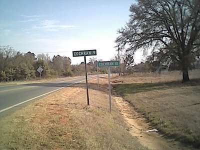
Yesterday, I received an e-mail from Joshua Jones, who found "The Georgia Road Geek" while looking for GA 400 exit information. He even included a very interesting photo that his mother, Alice Perkins of Cochran, GA, had taken while she was on her way home from work. Here's the photo:


Conflicting distance signs on US 129 ALT in the Hartford community near Hawkinsville, GA (Photo taken by Alice Perkins)

Is Cochran 9 miles from this point... or is it 10? Perhaps someone at the Georgia DOT could not make up their minds when they put these signs on this stretch of highway... so they figured they both can be right and they all lived happily ever after. :)

Seriously, folks, the "COCHRAN 9" sign was eventually removed and the other remained... but fortunately, not before Alice took this picture for posterity. A very special "thank you" to both Alice and Joshua for sharing this excellent photo with "The Georgia Road Geek".

As you have seen, "roadgeeking" can be a family affair, so, my fellow road enthusiasts, see if you can get your family into it as well. If you have a similar story you wish to share with us, then please e-mail it to georgiaroadgeek at bellsouth dot net.

Thanks for visiting, have fun "roadgeeking", and please come back often.


Friday, January 06, 2006

GA 400 Scenes From This Week (Part II)

Fellow road enthusiats, the saga continues...

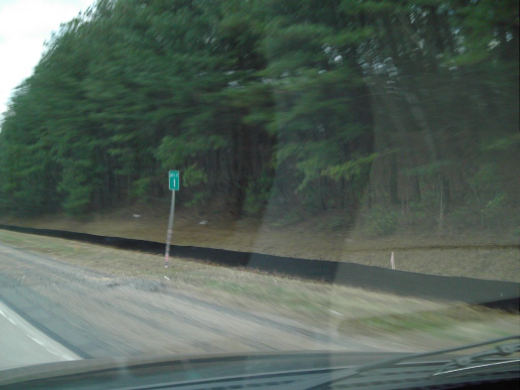
As you may remember from last time (Part I), we entered Forsyth County, where the GA 400 mileposts reset to zero. Now, here's "Mile 1", located just before McFarland Road East (Exit 12A)...

And now... here's your "roadgeek treat"... another GDOT "sign goof"...

Apparently, it must be 23 miles between McFarland Road East (Exit 12A) and McFarland Road West (Exit 12B). Either that or someone didn't tell the contractor that mile markers were reset just after entering Forsyth County.

Hope y'all enjoyed it. :)

Thanks for visiting and please come again.

GA 400 Scenes From This Week (Part I)

Fellow road enthusiasts...

This week, I decided to pack our second digital camera (the "cheapie" that we got free for getting BellSouth DSL) in the truck for some GA 400 "roadgeeking" during the commute home.

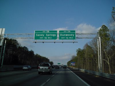
First, here is a picture of a new BGS overhead for Exits 5A-B (Abernathy Road) at the 1/2-mile (800 m) point...


As you may know by now, GA 400 will be widened between Holcomb Bridge and McFarland Roads. Here are photos for the GA 400 northbound lane shift that begins at Holcomb Bridge Road (GA 140)...


Here's a photo showing how traffic "bottles up" just 1 mile (1.6 km) before Haynes Bridge Road (notice the covered-up arrow)...

Here is where the northbound lane shifts will be ending for now...


This has been the northern end of the section of shoulder buses are allowed to use if traffic slows below 35 MPH (55 km/h).

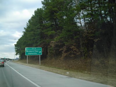
Finally, here are the northbound pictures from Forsyth County, starting with the point at the county line where the mileposts reset to zero...


On "Part II", I'll continue the pictures through McFarland Road and I will have a very special "roadgeek treat" for y'all.

That's all for now. Thanks for visiting and please come again.

Wednesday, January 04, 2006

We're Now On Mob-Rule

Fellow road enthusiasts, my wife and I just got our Mob-Rule user IDs.

She is "flagal" (for "Florida Gal") and I am, of course, "georgiaroadgeek".

Again, being an unabashed roadgeek, I enjoy driving the roads of places I have visited and do so whenever possible.

Here are the map URLs for each state and each county where I have driven a motor vehicle:

Alabama
California
Florida
Georgia
Minnesota
Mississippi
Nevada
North Carolina
South Carolina
Tennessee

Thanks to Mike Nix (Mob-Rule ID "michaelj" and currently ranked #2 on Mob-Rule), Alex "Roaddog" Nitzman (Mob-Rule ID "aaroads"), and Michael Adams for their additional encouragement and feedback regarding our newfound endeavors.

A final "thank you" to my brother-in-law Lib for his blog about my blogsite. He's right about my lifelong obsession with roads and road-related stuff. :)

That's all for tonight. Thanks for visiting and please do so often.
Monday, January 02, 2006

Countdown To "D-Day" On GA 400

Fellow road enthusiasts, it's the countdown to "D-Day" on US 19/GA 400.

On Tuesday, January 3, 2006, at 9 PM, the Georgia DOT (GDOT) will start the lane shifts on US 19/GA 400 northbound between Holcomb Bridge Road (Exits 7A-B) and Windward Parkway (Exit 11). The southbound lane shifts will start Wednesday night at 9 PM.

For more info, please click here for the article from the Atlanta Journal-Constitution.

Since just after Thanksgiving, GDOT has had mobile signs along GA 400 warning drivers that there will be construction activity from 9 PM until 5 AM.

This is the start of the much-needed widening of GA 400 between Holcomb Bridge Road in Roswell to McFarland Road (Exits 12A-B North, Exit 12 South) in south Forsyth County.

The good news is that this will not be a tolled "public-private initiative" project. :)

GDOT estimates a September, 2007, completion date. Still, this has been looooong overdue.

That's all for now. Thanks for visiting and please come back again.

Sunday, January 01, 2006

"County Counting"

Recently, my wife and I found a "county counting" website called Mob Rule, where you can create maps documenting each county within the U.S. that you have ever set foot into.

My wife has decided to document each county that she has physically been in, but being the roadgeek that I am, I have decided to document only those counties I have actually driven either through or into.

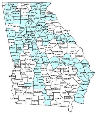
For instance, here is a map (generated from Mob Rule) showing which Georgia counties (shaded in blue) I have actually driven either through or into:

I also have created maps of counties I have driven either through or into for the following additional states: Alabama, California, Florida, Minnesota, Mississippi, Nevada, North Carolina, South Carolina, and Tennessee.

If I were to count other counties that I have set foot into, I could count counties in Alabama, Arkansas, Arizona, California (Riverside), Florida, the District of Columbia, Georgia, Illinois, Kentucky, Louisiana, Maryland, Nevada, Tennessee, Texas, Utah, and Virginia.

Outside of the U.S., I can count every Ontario county and region on the Queen Elizabeth Way between Toronto and Niagara Falls. (While we were there, we took either public transit or tour buses.)

The whole idea of "county counting" actually came from Mike, a Toastmaster friend of ours who works as a county extension agent and has pursued this hobby for several years. He's so good at counties, he can tell you right off the top of his head the exact number of counties there are in the U.S. (Thanks, Mike, for your inspiration.)

As I add more "driven-through" counties to my collection, I'll let you know.

That's all for now. Thanks for visiting and please come back again.

Holiday Roadgeeking 2005

Happy New Year, fellow road enthusiasts!!!

During the Christmas holiday, Mary and I went down to Florida to visit her family.

While we were there (and traveling to and from Florida), we even did some "roadgeeking" and "cinched" Florida's Polk Parkway toll road (FL 570). Here's a photo of the Polk Parkway BGS just after entering from I-4 just northeast of Lakeland:

On our way to Florida, we got stuck on I-75 southbound near the merge with I-675 and we were crawling all the way to just south of McDonough. On the way home from Florida, the northbound I-75 traffic really stunk, too, all the way from just south of McDonough all the way to the I-675 split. Here's a photo we took on I-75 southbound near GA 138 (Exit 228) around 3 PM just 3 days before Christmas:


It seems that no matter what time of the day (or even time of the year), everytime we're on I-75 between Stockbridge and McDonough, the traffic just stinks. :(

I-75 between Tifton and Valdosta was a major mess, too, as Georgia DOT (GDOT) had it torn up for the ongoing widening projects. Parts of it between Tifton and Valdosta were narrowed down and the speed limit was 60 MPH (100 km/h). I'm looking forward to seeing it completed and hopefully, by the time we head to Florida next Christmas, the streches currently being widened will be.

Kudos to GDOT for suspending road work during the holidays, though. :)

That's all for now. May you and yours have a very happy and prosperous 2006, thanks for reading and supporting "The Georgia Road Geek", and please come back again.

Wednesday, December 21, 2005

Holiday Wishes To You

Dear Fellow Road Enthusiasts,

Whichever holiday you choose to celebrate and observe, I wish you...

- A Merry Christmas
- A Happy Hannukah
- A Happy Kwanzaa

If I have forgotten a holiday that you choose to celebrate and observe during this time of the year, then I hope that it is a happy one for you.

Thank you for reading and supporting "The Georgia Road Geek" and may you have a safe and Happy New Year!!!

Saturday, December 17, 2005

Rediscovering Roadgeeking

Dear Fellow Road Enthusiasts,

When I decided to start a "roadgeek blog" of my own, I never imagined that it would be such a hit.

For the last 3 years, I was heavily involved in my other great love, Toastmasters. During this time, I was the Georgia Toastmasters District's Lt. Governor and finally District Governor.

On July 1, 2005, I officially became a "has been" and that freed me up to take up other hobbies that I enjoy... especially "roadgeeking". I am still active in my local Toastmasters chapter in the Atlanta area, but I'm just a member now. Oh, what a feeling!!! :)

My love of "roadgeeking" was rekindled in late August, when my wife Mary and I were in Toronto for the Toastmasters International convention. During our trip there, I decided to put our new digital camera to work by taking some road sign photos. Since that was the first time we ever went to Canada, I figured that I'd be cheating myself if I didn't "roadgeek" some.

Not long after coming back to Atlanta, I decided to do something different in terms of my "roadgeeking". That's when I decided to do a "blogsite" (with some inspiration from my brother-in-law, who had been blogging for a while himself).

First, I went to Blogger and set up this blogsite. Second, I went to Yahoo! Small Business and purchased the domain name georgiaroadgeek.com. Finally, I started blogging, and (pardon the cliche) the rest is history. :)

Now, here are some acknowledgements..

First, I want to thank my brother-in-law Lib for inspiring me to blog in the first place. Incidentally, he and my sister Laura had taken the world's only known "roadgeek" pictures from Kazakhstan while they were there to adopt their lovely daughter (my niece) Stella.


"CTON" is Russian for "STOP".

Second, I want to thank fellow road enthusiasts Geoff Hatchard, Pete Jenior, Adam Prince, J.T. Legg, Marc Fannin, "Froggie", Andy Field, Alex "Roaddog" Nitzman, and the rest of the road enthusiast community worldwide for supporting "The Georgia Road Geek".

Finally, I want to thank the love of my life and my best friend in the whole wide world... my lovely wife Mary. No matter what, she is always there to give me love, support, and encouragement. Honey, I love you more than anything else in the world! :)

That's all for today. Thanks always for visiting "The Georgia Road Geek" and please do so often.

Friday, December 16, 2005

"Georgia Road Geek" News - 12/16/2005

"411 Connector" Update

According to a Rome, GA, radio station website I came across yesterday while "Googling" for "411 connector" (I forgot the actual station name.), here is the latest news I have:

If all goes according to Georgia DOT's schedule, the land acquistion for the "411 Connector" in Bartow County will begin in 2006.

Actual construction may not begin until 2007 and completion may not be until 2010 at the earliest.

Georgia's First PPI Approved By DOT

Yesterday, the Georgia DOT's State Transportation Board unanimously approved the Public-Private Initiative (PPI) proposal from a consortium called Georgia Transportation Partners to add toll lanes along the Northwest Corridor (I-75/I-575 in Cobb and Cherokee Counties).

This will be Georgia's very first PPI. To learn more, please click here for the GDOT's official press release.

That's all for now. Thanks for visiting and please do so often.
Wednesday, December 14, 2005

Aerial Road Shot of the Week - US 41/411 Interchange

For the latest installment of "The Georgia Road Geek" Aerial Road Shot of the Week, we give you the US 41/GA 3 and US 411/GA 20 interchange near Cartersville (Bartow County):


Above Photo From Terraserver-USA.

This trumpet-style interchange was built around 1960 as the easternmost portion of a 4-lane divided highway (no access control) running from Cartersville to US 27/GA 1/53 in Rome (Floyd County).

The 4-lane divided highway in the southwestern corner is US 411 South/GA 20 West, which runs westward for 20 miles (32 km) to US 27/GA 1/53 in Rome. This particular stretch of highway was originally co-signed with US 411 as GA 344 until the mid 1970's.

US 41/GA 3 is the 4-lane divided highway that runs from northwest to southeast. US 41/GA 3 and US 411/GA 20 share pavement for 3 miles (5 km), where it meets GA 61. From there, US 411 joins GA 61 northward to the Tennessee state line and GA 20 splits eastward toward Canton (Cherokee County).

Future plans for this interchange are to tie in a brand new 4-lane divided highway with limited access that will extend the US 411/GA 20 4-lane highway to I-75 at GA 20 (Exit 290). This will be known as the "411 Connector". To see the route that the Georgia DOT (GDOT) has apparently chosen as of December 1, 2005, please click here for a detailed aerial map on their website.

The purpose of the "411 Connector", which was originally conceived in 1986 and later became part of the now-defunct "Northern Arc", will be to give both Atlanta and Rome direct high-speed access.

Based on my observations of the proposed route and design, it looks like the "411 Connector" would be up to Interstate standards from the existing US 411 4-lane to I-75. In that case, perhaps GDOT could designate this short stretch as I-375 (similar to either Alabama's I-359 in Tuscaloosa or I-759 in Gadsden).

Furthermore, perhaps GDOT could consider upgrading the existing US 411 4-lane between US 41/GA 3 and US 27/GA 1/53 in Rome to a full-blown Interstate, thus giving Rome it's own Interstate highway similar to Columbus's I-185.

Unlike the proposed I-3 in eastern and northeast Georgia, this highway IMHO is truly needed for giving Rome/Floyd County much better access to Atlanta as GA 316 did with Athens/Clarke County. My only hope, though, is that the developers don't get too greedy along the US 411 corridor, but given their track record and north Georgia's overall growth, I wouldn't bet the farm on it.

That's all for now. Thanks for visiting and please do so often.

Tuesday, December 13, 2005

STOP I-3!!!


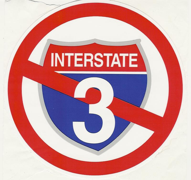
This afternoon, I received the above "STOP I-3" sticker from an acquaintance in Hiawassee, Georgia, located in the Blue Ridge Mountains of northeast Georgia near the North Carolina state line.

For those of you who may not know, there is a proposal to build an Interstate 3 (a.k.a. "The 3rd Infantry Division Highway") from Savannah, Georgia, to Knoxville, Tennessee. For more information on this proposed highway, please see AARoads Interstate Guide I-3 webpage.

Like many proposed routes, "economic development" is used as the justification, but several residents in Hiawassee, which will be in the path of I-3, are already rallying against the road due to the potential environmental damage it could bring to the Appalachian Mountains of Georgia, North Carolina, and Tennessee. The Stop I-3 Coalition was formed for this purpose.

Even though I am a road enthusiast, I am not really sure that I-3 would serve any real purpose. Hiawassee is already benefitting from the increasing number of retirees that move there for the peace and quiet, thus I feel the "economic development" argument does not quite hold water.

If we have any more news on the I-3 plans, then we will share them with you.

What are your thoughts? Pro or con, please feel free to post them here at "The Georgia Road Geek" (please keep the comments polite, however).

BTW, "STOP I-3" bumper and window stickers are available through the coalition's website.

That's all for now. Thanks for visiting and please come back again.


Saturday, December 10, 2005

Aerial Road Shot of the Week - 12/10/2005


Dear Fellow Road Enthusiasts,

After taking some "virtual trips" on some of Georgia's highways via Terraserver-USA, plus being inspired by Michael Adams's "Highway Heaven" aerial shot features, I decided to start an "Aerial Road Shot of the Week".

These will feature various highways throughout the State of Georgia.

This week's feature is an aerial shot of the interchange between US 23/GA 365 and US 441/GA 15 in Cornelia.

Above image obtained from Terraserver USA website.

From this point northward, US 23 and US 441 share pavement until they reach Sylva, North Carolina.

US 23/441 from Cornelia to the North Carolina state line make up the northernmost portion of Georgia's US 441 Governor's Road Improvement Program (GRIP) corridor (GDOT Project EDS-441). This GRIP corridor runs southward along US 441 to the Florida state line.

To the southwest of this interchange, US 23/GA 365 takes you to Gainesville, where, at the interchange with US 129 North/GA 369 (Exit 24), it becomes I-985.

Please let us know if you enjoy this feature and feel free to make your own suggestions for our "Aerial Road Shot of the Week" by e-mailing georgiaroadgeek at bellsouth dot net. As a token of our appreciation, we'll even mail you an official "Georgia Road Geek" magnet if you give us your postal address. :)

Thanks for visiting and please do so often.