While I was there, I noticed that ALDOT had a section regarding a proposal to extend I-85 from I-65 to I-20/59 along the US 80/AL 8 corridor.
According to the AARoads Interstate Guide website, this was supposed to be a part of a Congressionally proposed Interstate 14 corridor that would run through the "Black Belt" of Louisiana, Mississippi, Alabama, Georgia and South Carolina. Please click here for the proposal from the official website of Georgia Congressman Charlie Norwood.
For years before this proposal was made, I had originally envisioned Interstate 14, a route that would start at I-85 in eastern Alabama near Tuskegee, parallel US 80 from there to Phenix City, and into Georgia through Columbus, Macon/Warner Robins, and ending just west of Augusta at I-20 in Columbia County. This would be my own "Fall Line Freeway".
Based on ALDOT's proposed I-85 extension, I think it would make sense to keep it as part of the proposed I-14 corridor, with I-14 using the southern Montgomery bypass freeway (AL 108)as part of its route and I-14 and I-85 sharing pavement eastward until you reach the Tuskegee area. At that point, I-14 would run along a new route (parallelling US 80/AL 8) that would tie it into the existing Phenix City/Columbus northern bypass. Please click here for an ALDOT PDF file of the proposed I-85 extension study area.
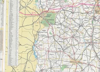
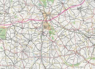
Here are images of my own I-14 Georgia route proposal as drawn on an official Georgia road map (my proposed route is in pink highlighter):


From Phenix City, AL, I-14 would use the existing US 80 Columbus/Phenix City northern bypass (known as J.R. Allen Parkway in Georgia), the northeasternmost part of the Columbus-Manchester Expressway (US 27 Alt/GA 85) into Harris County, then just south of Waverly Hall, it would proceed eastward, paralleling US 80/GA 22 all the way to I-75.
I-14 would cross I-75 just south of Hartley Bridge Road (I-75 Exit 155) in Bibb County, putting it between the downtown areas of Macon and Warner Robins.
From I-75, I-14 would proceed into Twiggs County, where it would cross I-16 and then go northeastward toward US 441 /GA 29, crossing it just south of Milledgeville and Baldwin State Forest.
Before reaching its final end at I-20 just east of US 221/GA 47 (I-20 Exit 183) in Columbia County, it would go north of the cities of Sandersville and Gibson, which are the county seats of Washington and Glascock Counties, respectively.
One advantage of having an I-14 would be to give central Alabama and central Georgia a high-speed way to get to and from Augusta and points eastward (Columbia, Florence, and Myrtle Beach, SC) without having to go through the Atlanta area, thus hopefully alleviating some of Atlanta's traffic woes. For example, to travel from Montgomery to Augusta via interstate, you would have to go I-85 to I-285 to I-20, putting you right smack-dab in a potential Atlanta gridlock situation.
Roughly, I estimate the distance of my proposed I-14 within Georgia to be 190 miles (304 km).
PLEASE NOTE: This is only the opinion of "The Georgia Road Geek" and does not represent in any way, shape, form or fashion, any official plans that the Georgia DOT may or may not have.
In the meantime, please feel free, my fellow road enthusiasts, to share your thoughts and ideas.
That's all for now. Thanks for visiting and please do so often.

6 comments:
While an interstate along your I-14 would be nice from a system perspective, I just don't see the traffic need along the corridor, ESPECIALLY along US 80 west of Selma. Traffic there barely justifies 4-lane widening, let alone an Interstate.
And I certainly don't buy the "economic development" argument either....that shouldn't even be a consideration IMO in this day of tight transportation budgets. Put the money where the *NEEDS* are, not at the "wants".
Besides, if transportation access is all it takes for economic development, one would think I-20/59 at the Tenn-Tom would be a booming place.
It isn't.
My original proposal was to extend I-16 to Montgomery and then build a cut-off along SR 96 known as I-216/GA 418. For some reason, the Augusta route did not even cross my mind. IMO, middle GA isn't growing as much in part because it's underserved by interstates. Augusta, Columbus, Macon and Montgomery SHOULD be tied together by interstates, and a south by-pass of Atlanta would help.
I believe that I-14 should follow the route of Hwy 96 - of course bypassing the small towns and that would create a south bypass for Macon and Warner Robins. There are few crossings of the Ocmulgee River and your proposal would displace a lot of people south of Macon, and also traffic is bad in the area of I-475 on the south side - building another interstate there would make it worse. But I believe I-14 is a great idea - it would make it even easier to get to Columbus, and it would save a lot of time to Augusta - also it would create a lot of jobs along the way to places that need it.
GA RD Geek - I think you're own the right track. U.S. Department of Transportation estimates that every $1 billion of investment in federal highway construction brings approximately 42,100 full-time jobs with it to those areas along the route. I agree with some of your suggested routing, but I believe that from a budgetary standpoint, southerly routes around metro areas like Macon, Columbus, and Montgomery would be more cost effective in ROW acquisitions. Columbus in particular needs better transportation to southern metro areas. Due to Homeland Security, the main route, I-185 thru Benning, is subject to be closed at any time given some threat levels.
Interstate 14 would bring much needed development to the small towns along the way in Ga and Al. The money will be spent it might as well be all through middle Ga.
I14 is a great idea, i would bridge the gap in a lot of areas, i tough getting thru macon from the westside to the eastside with all the traffic lights, and Columbus is just as bad. Is is well over do.
Post a Comment