As promised, I have produced the final episode of "ROADGEEK-CAM!!!" for 2006.
This episode features various and sundry Florida road scenes from December 23-26, 2006.
Please click here to view. (NOTE: DSL-or-faster connection recommended.)
This will be my final entry for 2006, so again, I thank you very much for reading my blogs and watching my videos, and may you and yours have a happy, safe, and prosperous New Year.
Saturday, December 30, 2006
Friday, December 29, 2006
Reflections On 2006... And Cars
This has been a very good year for "The Georgia Road Geek".
From what started one year ago October as simply a blog, I had decided to make it a full-fledged roadgeek website complete with Special Feature Pages highlighting some of the trips and other road-related things that interested me, plus my series of road videos I produced into "ROADGEEK-CAM!!!". Look for more blogs, "ROADGEEK-CAM!!!", and perhaps another new feature I am thinking about adding to "The Georgia Road Geek".
Roadwise, I clinched Georgia's I-185 and I-575, plus clinched all of I-85 from Montgomery, AL, to Petersburg, VA, plus driven hundreds more interstate miles in Virginia, North Carolina, Maryland, and the District of Columbia.
Countywise, I clinched several more counties in Georgia, Alabama, North Carolina, Virginia, Maryland, and even the District of Columbia.
Next year, I hope to clinch I-20 and I-520 within Georgia, plus some counties and interstate miles in Arizona.
What amazes me the most is the number of people who have read my blogs and watched my videos. Many of these people have even requested my "Georgia Road Geek" magnets and I have mailed several of them to people throughout America. I can never thank you, dear reader, enough for your visits to my blogsite and your support will never, ever go unappreciated.
Last, but never least, I have to give a major, major "thank you" to my biggest fan and best friend in the whole wide world... my wife Mary.
One final thing before completing tonight's blog...
Mary and I finally broke out the "Cars" DVD and watched it. The computer-animated movie, created by Disney/PIXAR (whose other creations include "Toy Story", "A Bug's Life", and "Finding Nemo"), features the voices of Paul Newman, Larry The Cable Guy, Richard Petty, Dale Jr., and a whole bunch of other famous folks. It also features excellent songs such as "Life Is A Highway" and the legendary Bobby Troup-composed song "Get Your Kicks On Route 66".
I appreciated the movie's story line, its glorification of the "mother road" Route 66, and its excellent animations of roads, expressways, and roadsigns. There was a moment in the movie that tugged on my "heart strings" as James Taylor (one of my all-time favorite singer/songwriters) sang "Our Town", a lament of the old towns along the road falling victim to the Interstate (in this case, a ficticious western town "Radiator Springs", which fell victim to I-40). After watching "Cars", I soooo want to go back westward and visit parts of this venerable old highway. If you haven't watched the movie yet, then IMHO, you've missed out on one of the greatest movies made in the past few years. :)
Overall, I feel that 2006 has been a very good year and again, I thank each and every one of you for all your support of my work on "The Georgia Road Geek", and may you and yours have a very happy, safe, and prosperous new year.
P.S. I got material for one more "ROADGEEK-CAM!!!" and I'll try to get it produced and uploaded for y'all this weekend. Thanks again!
Thursday, December 28, 2006
"ROADGEEK-CAM!!!" - I-75 Northbound 12/26/2006
Here's another episode of "ROADGEEK-CAM!!!" for you.
This time, we compiled and edited videos taken on I-75 northbound between GA 27 (Exit 112) and I-475 (Exit 156).
Please click here to view it. (NOTE: DSL-or-faster connection recommended.)
Stay tuned for the next episode, which will contain other Florida road scenes taken over the Christmas weekend.
Thanks for viewing and hope y'all enjoy.
Wednesday, December 27, 2006
"ROADGEEK-CAM!!!" - Florida's Polk Parkway

As promised yesterday, I deliver to you, dear readers, my Polk Parkway (Toll FL 570) edition of "ROADGEEK-CAM!!!". Please click here to see it. (NOTE: DSL-or-faster connection recommended.)
The footage was shot on Christmas Eve as Mary and I were traveling the eastbound section of the parkway from Harden Boulevard (FL 563) to its eastern end at I-4.
A very special thanks to my wife Mary for financing the tolls and always for supporting my "roadgeeking". :)
Thanks in advance for watching and I hope you enjoy it.
A Salute To C.W. McCall
Last month, I found and bought online a Mannheim Steamroller (MS) CD "American Spirit", featuring the legendary C.W. McCall. It can be ordered directly from MS by clicking here.
As Mary and I were heading to and from Florida, we listened to this CD and it really struck a chord in my "roadgeekness" with the songs "Wolf Creek Pass", and of course "Convoy". :)
Now you may wonder, "What does C.W. have to do with Mannheim Steamroller (and vice versa)? Here's the story...
In 1972, Chip Davis ("Mannheim" creator) and Bill Fries (a.k.a. "C.W. McCall") were both working for an Omaha advertising firm. Together, they created the ficticious trucker C.W. McCall, and created some local commercials around this character.
In 1975, Davis and Fries released the first C.W. McCall album "Wolf Creek Pass", and one year later (1976), they released the song "Convoy", a ficticious story of truckers "Pig Pen" and "The Rubber Duck" (C.W.'s CB "handle") crossing the nation in a huge convoy and defying the "bears" (police) while talking on to each other on their CB radios. "Convoy" was the catalyst for the 1970's "CB craze", and soon enough, Americans were buying CB's (originally with 23 channels, later expanded to 40) like hotcakes.
I was 12 when "Convoy" came out, and my dad bought us a 23-channel Cobra CB at the Naval Air Station Atlanta's PX while he was in the Naval Reserves as an aviation electronics tech (2nd class petty officer). Once he got it hooked up in our car, I couldn't wait to get on. I even had my own "handle" ("The Rattler", a name that I thought was cool at the time). We had a great time going between Atlanta and Florida giving/receiving "smokey reports" (reports of police cars spotted along the road) and "ratchet-jawing" (talking) to other CBers. Little did I realize at that time how "Convoy" would influence me as a roadgeek. :)
Radiowise, I gravitated away from CBs by 1980, but in 1987, I studied for and earned my Amateur (Ham) Radio license (callsign KC4AZO), which I have proudly held since. Ham radio and roadgeeking have since become 2 intertwined passions of mine.
BTW, my dad bought the CB rig when the FCC still required licenses for each rig. All you had to do, though, was fill out the application, mail it to the FCC (as opposed to taking a test), and they mailed you back a CB callsign. Our CB callsign was KAMX 5963. Soon afterward, the FCC dropped CB licensing requirements, and sadly, CB became an anarchistic "free-for-all". :(
Roadwise, I will be forever grateful to Mr. Davis and Mr. Fries for "C.W. McCall", for their songs "Convoy" and "Wolf Creek Pass". Everytime I hear them, especially "Convoy", I always pine for traveling up and down the highways that have changed America and, in their own way, contributed to the prosperity of this great nation and allowed us, as roadgeeks, to explore this nation in ways the common folks could never do as they do now.
God Bless America, God Bless America's Roads, and God Bless the Great American C.W. McCall!!!
LET THEM ROADGEEKS ROLL, 10-4!!! :)
Tuesday, December 26, 2006
I-75 Northbound Shut Down!!!
After nearly 12 hours on the road, we're back from Florida.
We had a wonderful time with her folks and even worked in some "roadgeek time" around Lakeland and Polk County for some video shots of the Polk Parkway (Toll FL 570) for its own episode of "ROADGEEK-CAM!!!".
I also shot some potential "ROADGEEK-CAM!!!" video footage in other various spots between Atlanta and Lakeland, enough to produce at least 2 additional episodes (one for Georgia and another of various Florida road scenes). My goal is to put these together this week and have them ready for y'all by New Years Day.
Now, here's the story about our journey tonight between Macon and Atlanta...
On our way home this evening, I-75 northbound was absolutely shut down due to all lanes being blocked at Exit 205 (GA 16/Griffin/Jackson). We encountered the traffic jam just before Exit 193 (Johnstonville Road) in Monroe County, and exited I-75 at Exit 198 (High Falls Road). The whole mess eventually resulted in a traffic jam that extended from Exit 218 (GA 20/81/McDonough/Hampton) all the way down to I-475!!!
To get around it, we took High Falls Road east to GA 36 east, which took us into Jackson. From Jackson, we took US 23/GA 42 through Jenkinsburg, Locust Grove, and into McDonough. From the McDonough town square, we proceeded west on Jonesboro Road, which took us back to I-75. I will admit, however, that I enjoyed riding these "roads less travelled" and enjoyed going through these quaint old towns that the Interstates by-pass. :)
For now, here is a special "blog reader only" video of I-475 southbound near Macon. (NOTE: This will not be available via "ROADGEEK-CAM!!!" or elsewhere on the website.)
Hope y'all had a Merry Christmas, thanks for reading, hope y'all enjoy the video clip, and please come back again.
Friday, December 22, 2006
Merry Christmas 2006
"Have you finished your Christmas shopping yet?"
How many times have you been asked (or asked by others) that particular question?
Well, dear readers, my wife and I have definitely finished our shopping and are getting ready to make the annual Christmas trek to Lakeland, Florida, to visit her parents. Regretfully, we will not be able to see her sisters, Polly and Becky. Polly, who lives in Orlando, has the flu and Becky has to be back in Tallahassee by the time we get down there. We'll miss them terribly. :(
Polly, Mary and I wish you a speedy recovery.
Becky, Mary tells me that you've visited my blogsite (thanks for doing so) and almost ordered one of my official "Georgia Road Geek" magnets. Yes, I really do send them to folks, and many a magnet have found a home in places all over America. In fact, I'll go ahead and mail you one ASAP. :)
If we get some spare time, and the weather cooperates (60% chance of thundershowers according to The Weather Channel), we might get some more Florida "ROADGEEK-CAM!!!" footage.
We, the staff at "The Georgia Road Geek", wish you and yours safe travels and a very Merry Christmas.
Thanks for reading and please do so often.
Saturday, December 16, 2006
I-185 To Albany and Tallahassee?
According to Albany's WALB-TV, the Georgia DOT is getting ready to pay approximately $500,000 to consultants to study the feasibility of extending I-185 from Columbus/Fort Benning to Albany, Thomasville, and Tallahassee. For the article and news video clip, please click here. (URL provided by Brian Holt via the Yahoo! seroads newsgroup.)
During the 1980's, GDOT already spent millions of dollars to 4-lane a stretch of road from Columbus to Albany, Tifton, Waycross, and Brunswick (GA 520 - South Georgia Parkway) as part of its Governor's Road Improvement Program (GRIP) for the same reason that the I-185 extension proposal is being made... economic development. In fact, the proposed I-185 extension, if built, would follow GA 520 from Columbus to Albany, then follow US 19/GA 300 (Georgia-Florida Parkway), and then US 319/GA 35 down to Tallahassee, all 3 routes that already have been 4-laned as part of the GRIP program.
According to the article, there is already heated debate within Southwest Georgia as to whether or not to extend I-185 through their region. Thomas County leaders have gone on record as being in opposition, saying that they already have enough "federal roads"(US 19, US 84, and US 319, all GRIP corridors BTW).
Here's how I sum it up.... if you already have spent millions of dollars 4-laning existing roads and you are not seeing the benefits, then I seriously doubt that sinking more into upgrading them to Interstate standards are going to help (long- or short-term). Furthermore, the limited amount of road funds we already have (federal, state, and local) need to be concentrated more on areas with real traffic problems such as Metro Atlanta (the economic engine of Georgia and the South) and the improvement of I-75 and I-95 (significant Eastern U.S. major north-south traffic corridors).
Here's an idea... if Southwest Georgia wants a new limited-access highway so bad, then why don't they try to convince a private outfit to engage in a "public-private partnership" with GDOT to build a toll road (similar to Virginia's Dulles Greenway). Heck, I'll even draw up a route free of charge, under the condition that this road be named the "Steve Williams Southwest Georgia Turnpike". If you think that such a road can pay for itself with collected tolls (especially from trucks that could use it to bypass I-75), then, design it and build it. If not, then just put the whole thing to rest and be satisfied with what GRIP and our tax dollars already got you.
But the "roadgeek in me" says that, if I-185 ever does get extended (which I doubt will happen anytime soon), that would be more Interstate miles for me to "clinch". :)
That's my $0.02 for today. Thanks again for reading and please do so often.
Friday, December 15, 2006
The Map Dot Saga Continues
First of all, dear readers, I must acknowledge fellow Georgia road enthusiast Stanley (SC) of Sandy Springs for his observations regarding where Johns Creek should be recognized along US 19/GA 400 northbound.
In his comment posting, he suggested that Johns Creek should be recognized at Exit 10 (GA 120/Old Milton Parkway/Alpharetta). Good call, Stanley, and thanks for your input. :)
And now, the infamous Georgia highway map dot saga continues...
This past week, the Atlanta Journal-Constitution published an article stating that the Georgia DOT decided to "put back" those places that were removed for 2007 into the 2008 map... but only if they have a zip code. Please click here to read the full article.
The article lists all the places that were removed for 2007, and would you believe that Sandy Springs (yes, the new City of Sandy Springs) is one of the places to be removed. Now I may understand some of the places that GDOT decided on removing from the map, but, for crying out loud, Sandy Springs... one of Georgia's largest cities?!!!! Duuuude, what were they thinking?
IMHO, Sandy Springs, a place that fought for over 30 years to become its own city and was finally granted its charter last year, is being insulted by this omission. Again, Sandy Springs is one of Georgia's largest cities (population 87,000, which makes it roughly the same size as Albany and Roswell). Sandy Springs's leaders fought long and hard for their "independence" from Fulton County, thus the least the state could do is acknowledge their very existence on Georgia's official maps.
In other Georgia road news...
- I-85/GA 316 interchange design image now available from GDOT. Please click here to see it.
- GDOT has completed environmental and historical impact studies for Bartow County's US 411 Connector, a limited-access facility which will connect the US 411/GA 20 4-lane from its current trumpet interchange at US 41/GA 3 directly to I-75 at GA 20 (Exit 290). Right-of-way acquistion is expected to begin late next year (2007).
- On I-285 at Peachtree Industrial Boulevard (GA 141 -Exits 31A-B), I recently observed signs for a program called "Revive 285". According to the website, it's a joint GDOT/Georgia Regional Transportation Authority program aimed at addressing the "top end" from I-75 in Cobb County to I-85 in DeKalb County and I-75 from I-285 to Windy Hill Road. It'll be interesting to see what comes of it. :)
And finally...
To celebrate the Christmas, Hannukah, and Kwanzaa holidays, and in appreciation to you for reading my blogs, I yet again offer official "Georgia Road Geek" magnets free of charge. All you have to do is e-mail me your postal address (webmaster at georgiaroadgeek dot com), and I'll pop you one in the mail ASAP. (Limit one per person, please.)
That's all for tonight. Thanks for reading and have a great weekend... and Happy Hannukah to all our Jewish friends. :)
Saturday, December 09, 2006
Jammin' Road Videos
This morning, I watched another episode of "Dashboard Cinema" from New York road enthusiast C.C. "Comrade Mister Yamamoto" Slater... and, dude, the video I watched just had me "jammin', mon"!!! :)
This particular video was shot while he was driving through Poughkeepsie, NY. You gotta see it, and please click here to do so.
I was so inspired by Slater's video, that I dug up some early footage I shot while I was driving on I-285 near Dunwoody on my way home from work and made it the latest episode of "ROADGEEK-CAM!!!". Please click here to see it.
Kudos to Slater for his excellent road videos and I hope you enjoy mine as well.
That's all for now. Thanks for reading and please come back again.
Map Dots And More New Cities
This past week, there was a story on WSB-TV regarding communities that were removed from the 2006 official Georgia highway map. Please click here to read (and see).
It got me to thinking about the new North Fulton County cites of Johns Creek and Milton and where their dots would be on the next release of the Georgia map. Here is a comment I posted to a misc.transport.road discussion "Demapped In Georgia"...
Speaking of Georgia cities, it will be interesting to see where the dots for the new cities of Johns Creek and Milton (which officially became cities last Friday, 12/1) will go on the 2007 official Georgia roadmap. Sandy Springs, Georgia's other new city, always had a dot on the map, so that was not a question.
Both these new cities were created out of sections of extreme north Fulton County that didn't have squat as recent as the early 1990's. Like Sandy Springs, the folks in this section of Fulton County (mostly Republicans) wanted their "independence" from a government that just took their taxes and gave them virtually nothing in return (as least compared to the primarily Democratic southern end of the county).
Even with these new cities being created, there is still the possiblity of the "resurrection" of Milton County (which was merged into Fulton in 1932 due to the Depression). In the next session of the Georgia General Assembly, there's a possibility of a proposed state constitutional amendment that, if passed by the majority-Republican General Assembly, signed by Governor Sonny Perdue (an ex-Dem-turned-Republican), and approved by the voters statewide, will "resurrect" Milton County. (I assume at this point that Alpharetta would again be its county seat as it was in the old days.)
For all you "county clinchers" out there, it would be a potential opportunity. I would "clinch" it immediately since I drive through there everyday via US 19/GA 400.
If you are a registered Georgia voter and want another county to "clinch", just go to the polls when the referendum comes and "Vote Yes For Milton County". :)
Now that Milton and Johns Creek are officially cities, here is how and where I would mention it on the roadsigns...
US 19/GA 400 Northbound (From Roswell):
Exit 11 - Windward Pkwy/Milton (since Alpharetta is already mentioned at the prior 3 exits and you would have passed downtown by that point).
Exit 12A - McFarland Pkwy East/Johns Creek
US 19/GA 400 Southbound (From Cumming):
Exit 13 - GA 141/Johns Creek/Norcross
Exit 12 - McFarland Pkwy/Milton
From Peachtree Industrial Boulevard (PIB) I would change the overhead sign at the GA 141/PIB split near Norcross to read "Johns Creek/Cumming" instead of "Cumming/Dahlonega".
Since these cities already have significant populations (Johns Creek: 63,000, Milton: 20,000), they truly have the right to have their names mentioned so that people can easily reach them via our highways. Hopefully, GDOT will give them their dots as well. :)
BTW, I have spotted the first Milton city limit sign at GA 9 and Windward Parkway, but did not see one on GA 9 as you enter from Forsyth County.
Congratulations to the residents of these new cities on their incorporation and may they truly have a local government that will work only in the citizens' best interests.
When will Milton County be "resurrected"?
That's all for now. Thanks for reading and please come back again.
Sunday, December 03, 2006
Roads In My DNA?
Last Thanksgiving, as we (the Williams family) were gathered around the table at the Blue Willow Inn enjoying our dinner, my dad talked about how my grandfather would rent a beach house in New Smyrna Beach, Florida, and make the drive down there, wife, kids, and all.
Back in his day, there were no Interstates, just the US and state routes such as the legendary US 41. The particular comment he made was how he'd drive all night to get everyone back to Atlanta in time for him to go to work and how hardcore he was about driving.
On the Memorial Day weekend of 1997, my dad and I went down to the Kings Bay Naval Submarine Base to take a "tiger cruise" on my brother's sub, the USS Maine. That's a story in and of itself, but we sort of had the same deal where we had to be back to Atlanta. If I recall correctly, we left sometime around 9 PM and drove all night up I-95, I-16, and I-75. While my dad listened to a "book on tape", I pulled the "allnighter" by doing the driving. After that experience, my dad paid me one of the greatest compliments he ever paid me by dubbing me "The Road Warrior". :)
I'm no scientist, but these experiences have begun to make me wonder if my grandfather had roads in his DNA. If he did, then I feel honored and privileged that it got passed down to me.
I never really knew my grandfather for a long time (he died of a heart attack at age 65 and I was 10 at the time), but the few memories I do have of him during my early childhood in Snellville are those that I treasure. My siblings, cousins, and I knew him as "Papa" and today, my nieces and nephews know my dad as "Papa", so the honor has been passed down, in different ways, from my grandfather to my father (the "Papa" thing), and the "road DNA" got passed to me.
"Papa", thank you for the "road DNA". When I get to Heaven, I hope to be eternally crusing with you on their golden highways on the ultimate roadtrip. I know we'll have a great time doing so! :)
That's all for now. Thanks for reading and please come back again.
This column is dedicated to the memory of my grandfather, Frank "Papa" Williams (1909-1974).
Saturday, November 25, 2006
It’s The Road TO Roswell, Georgia - An Antebellum NOT Alien Town
This is a "special guest blog" written by Mary Williams.
I love working for the Historic Roswell Convention and Visitors Bureau. It’s a small operation, so we all have a chance to answer the phones. One of things that I do every day is to tell folks how to get from wherever they are to the historic sites in Roswell. I love to say that I have a job where I can tell people where to go and they appreciate it. If they tell me that they’re on Roswell Road, I learned very quickly to find out if they’re coming from Marietta (Hwy. 120) or from Atlanta (Hwy. 9). Both roads are named Roswell Road until you reach the city of Roswell where they change names to Marietta Hwy. and Atlanta Street, respectively. That’s where the confusion really starts.
If you’re coming from Buckhead (Atlanta), Hwy. 9 is called Roswell Road. In Roswell, alone, it becomes Atlanta Street, Alpharetta Street, and then Alpharetta Hwy. Once you’re in Alpharetta, it becomes Main Street and then Cumming Hwy. when you get north of downtown. At the Forsyth County line, it becomes Atlanta Hwy.
This all makes perfect sense to me – each time the road name changes, generally you’ve driven into or out of a city jurisdiction and the road name changes to reflect that it’s either the road TO or the road FROM whatever city name it now carries. This is very confusing to those from out of town, especially those from towns where a road carries the same name from beginning to end.
I’ve found out that this road name changing can even be confusing to others in the tourism industry. One day, I received a phone call from a tourist, looking for Chastain Park. She’d called Atlanta and they’d given her our number because they were sure that since Chastain Park is off of Roswell Road that it must be in Roswell. I explained that Roswell Road is the road TO Roswell, not a road in Roswell, and that Chastain is a city of Atlanta park.
I thought this was an isolated event, until I received a phone call a couple of weeks later from someone who works for Atlanta, asking about Chastain Park. She insisted that it was in Roswell, so I patiently explained that no, it was in Atlanta. She told me that that was impossible, because it was on Roswell Road so I got to explain, once again, that Roswell Road is the road TO Roswell and not a road in Roswell.
I also receive phone calls where folks ask what exit number are we off of I-75 or GA 400. Exit numbers don’t do anything for me. I visualize roads by their name. I see Hwy. 92 (the road from I-75, through Woodstock which becomes Woodstock Road, Crossville Road, and eventually Holcomb Bridge road before you get to GA 400) instead of an exit off of I-75. Maybe that’s a northern thing??? I can remember my trips to New Jersey on business where all directions were given as exit numbers off the New Jersey turnpike. When I’d ask what the road name was, up there, I’d get a blank stare.
Probably the most amusing geography anomaly that we have is the name of the city, itself. Roswell Georgia is an antebellum (before the Civil War) town, just north of Atlanta. During the Civil War, the only structures that were burned were our cotton and woolen mills
Roswell is more of a common town name than I’d realized. One day, a young man came into the Visitors Center. His name was Roswell and he had a goal to visit each of the towns in the United States that had that name and to get a souvenir from each. I can’t remember the exact number of Roswells that he told me, but it was over 20.
Each year, Roswell, New Mexico holds their alien festival. In the months that lead up to that event, we receive quite a few phone calls that ask about our alien festival. It’s happened so frequently that I think we need to design a t-shirt that shows an alien in antebellum dress with the title “Roswell – antebellum, not alien” on the shirt. So far, no one has agreed with me.
Thank you for letting me guest-host a blog on my amusing (well, to me, it’s amusing) experiences with the geographically-challenged public.
NOTE FROM STEVE:
Mary and I have been married for nearly 3 1/2 years, and she has worked for the Historic Roswell CVB for nearly 5 years.
Mary has been very supportive of my "roadgeeking" and I was quite pleased when she offered this "special guest blog" for posting.
I hope you have enjoyed reading it and thank you for doing so. Please come back again.
Friday, November 24, 2006
Thanksgiving In Social Circle
Yesterday evening, Mary and I met my folks, my sister and brother-in-law, and their little girl (our niece) Stella at the Blue Willow Inn in Social Circle for an absolutely wonderful time with family and a really delicious Thanksgiving dinner, southern-style of course. :)
Social Circle, a quaint little town in south Walton County, is located on GA 11 just 10 miles (16 km) south of the Walton County seat of Monroe and approximately 50 miles (80 km) east of Downtown Atlanta. If you are coming from Atlanta, take I-20 to Exit 98 (GA 11/Monroe/Monticello), turn left, and Social Circle will be just 4 miles (6 km) to the north.
The Blue Willow Inn is in an old southern-style mansion reminiscent of the fictitious Tara plantation in Margaret Mitchell’s novel “Gone With The Wind”. Ms. Mitchell herself was a frequent visitor to Social Circle and, in 1922 actually courted her first husband, Berrien “Red” Upshaw, at that particular house, which Upshaw’s family owned at the time. Nowadays, the Inn is known more for its excellent southern-style food, of which I am now one of its proud advocates. Not only will you enjoy the food, but you will also enjoy the ambiance of the place and the courteous “southern hospitality”.
Now, let’s go to the “roadgeek” part…
At around 6 PM last night, we departed from Loganville on US 78/GA 10 to the GA 10 Business (West Spring Street/Monroe) exit and went through Downtown Monroe, where we picked up GA 11 and proceeded to Social Circle. By the time we got going, it was dark, so it didn’t lend itself to any good roadgeek photo or video footage IMHO. This was the first time in 9 years that I have traveled that stretch of highway, the last time being to go to Monroe for a funeral of a distant cousin that my mother was close to during her childhood.
My dad rode with us on the way over there and I tended to rattle off some road history (and even some railroad history) that I knew regarding Monroe and Walton County. He's always sworn I should’ve been a civil engineer, but I prefer just being a "roadgeek". (I did consider civil engineering at one time, but settled on computer science instead.)
Before the completion of GA 316 in 1995, US 78/GA 10 was the main Atlanta-to-Athens highway, and from 1965 through 1988, most of the highway between the east end of the Stone Mountain Freeway (originally the Stone Mountain By-Pass) and Athens was a typical 2-lane road.
Around 1965, the Georgia DOT opened a 4-mile (6 km) 4-lane divided limited access Monroe By-Pass, rerouting US 78 accordingly. This was also designated GA 10 By-Pass and remained so until the mid-1980’s, when GA 10 through Monroe was redesignated GA 10 Business and GA 10 was rerouted on US 78.
Around 1969, the remainder of the Stone Mountain Freeway (GA 410) was opened between the current Memorial Drive exit (Exit 5) and US 29/GA 8 just northeast of Decatur. US 78 was rerouted onto this new alignment accordingly and has stayed there since.
During the 1970’s and 1980’s, US 78/GA 10 was widened between Stone Mountain and Athens, mostly to 4-lanes with a middle left turn lane, but the stretch between Loganville and Athens was widened to a 4-lane divided highway. The last part of US 78/GA 10 between Atlanta and Athens to be widened was completed in Loganville in 1988, with a brand new stretch built on the western side of Loganville at the Gwinnett/Walton County line. The original stretch from the county line to GA 20 is now known as Logan Road.
GA 11 is a highway that stretches from the North Carolina line in Union County through Gainesville, Macon, and eventually the Florida line in Echols County. Monroe and Social Circle are on a “standalone” northern stretch that runs from US 129 in Jefferson back to US 129 in Gray.Besides this stretch and a stretch between southern Bibb County (where US 129 and US 41) split and Hawkinsville (Pulaski County), GA 11 shares pavement with US 129 throughout the rest of Georgia. In Berrien County, it shares a brief stretch of pavement with US 82/GA 520 (South Georgia Parkway/Corridor Z).
From Monroe to Social Circle, the northern portion of the shortline Great Walton Railroad parallels GA 11, crossing it just south of Monroe and again just north of Social Circle. The railroad itself ties into the main CSX line at Social Circle. This is a stretch of track that originally ran from Social Circle to Gainesville via Winder and Braselton. The track between Monroe and Gainesville was abandoned and removed nearly 60 years ago.
Mary and I enjoyed Social Circle so much that we swore that we’ll come back to Social Circle, preferably during the daytime, and check it out further, plus even do a little “roadgeeking”. :)
That’s it for now. Thanks for visiting, enjoy the rest of the Thanksgiving weekend, and please come back often.
Wednesday, November 22, 2006
Happy Thanksgiving 2006
Dear Reader,
I just wanted to let you know how thankful I am for you reading my blogs and for watching my "ROADGEEK-CAM!!!" episodes.
This afternoon, to avoid the gridlock on the "top end" of I-285, I decided to venture up GA 141 through Gwinnett and the new City of Johns Creek in North Fulton County.
Once I reached McGinnis Ferry at the Fulton/Forsyth County line, I noticed that the construction signs have already been placed in preparation for widening GA 141 between there and GA 9.
Last weekend, the Georgia DOT had been doing work on the southbound lanes between Windward Parkway and Holcomb Bridge Roads, but unlike the northbound work, they only shifted traffic to the far left into the 2 new left lanes instead of fully opening all of them to traffic. They still need to finish placing the overhead gantries and signs on both sides, not to mention reactivating the traffic cameras, replace the message boards, and get the ramp meters up and running. Still no word yet from GDOT on the ramp meters and I still need to follow-up on it. If anyone in GDOT reads this and has the answer, then please feel free to let me know at webmaster at georgiaroadgeek dot com.
And finally, here's a picture that my self-proclaimed "leaf-freak" wife Mary took a few weeks ago along GA 400 southbound near I-85 as we were heading down to Columbus...

That's it for now. Thanks again for reading, for watching "ROADGEEK-CAM!!!", and may you and yours have a very happy and safe Thanksgiving holiday.
Monday, November 13, 2006
First New GA 400 Northbound Lanes Open
Today (Monday) was the first day of the first set of new lanes to open on US 19/GA 400 northbound and here's the configuration...
- 4 lanes from GA 140/Holcomb Bridge Road (Exit 7A-B) to GA120/Old Milton Parkway (Exit 10).
- Just past Exit 10, traffic temporarily merges left, reducing the lanes to 3.
- 1/2 mile (800 m) before Windward Parkway (Exit 11), traffic again temporarily merges left, reducing the lanes to 2.
The bottleneck that did occur between Mansell Road (Exit 8) and Haynes Bridge Road (Exit 9) now occurs just before Exit 10.
At this time, we have no word regarding the new southbound lanes between Exits 7 and 11, but once we find out, we'll let you know.
As soon as I can, I'll be shooting some footage of these new lanes for "ROADGEEK-CAM!!!".
That's all for now. Thanks for reading and please come back again.
Saturday, November 11, 2006
I-185 Callboxes And GA 400 Status Report
 Callbox on I-185 northbound at mile 41.3 in Troup County.
In Georgia, I-185 is the only interstate with motorist aid callboxes.
The above pictured callbox, a solar-powered cellular unit, is one of 147 installed on a 40-mile (65 km) stretch from I-185's northern end at I-85 near LaGrange to just south of US 80/GA 22 (Exit 10 - J.R. Allen Parkway/Fall Line Freeway) in Columbus/Muscogee County.
In 1999, the U.S. Department of Transportation's Intelligent Transportation Systems Joint Program Office received a report on the effectiveness of these boxes. Please click here to read it.
IMHO, given the apparent success of the I-185 callboxes, I am somewhat surprised that such units are not installed on I-16, which contains longer desolate stretches as it makes it way from Macon to Savannah. If they have been successful on I-185, then why not install them on I-16? After all, not everyone may have a cellphone, or perhaps someone's cellphone may be dead, and this would give at least an option for a stranded motorist to get help if needed.
BTW, here's my latest episode of "ROADGEEK-CAM!!!" featuring I-185. (NOTE: DSL-or-faster connection recommended.)
And finally, US 19/GA 400...
This weekend, the Georgia DOT has been doing a massive push to complete the work on the new northbound lanes between Holcomb Bridge Road (Exit 7) in Roswell to Windward Parkway (Exit 11) in Alpharetta. Their goal, according to the Atlanta Journal-Constitution, is to have these lanes open to traffic on Monday morning. Please click here to read the article.
The construction also includes new ramp meter lights that have been installed on the ramps from Northridge Road (Exit 6) in Sandy Springs to Windward. A few months ago, I have sent GDOT an e-mail asking when they would become operational, but have not received a response. If I learn anything from any source I can find, then I will pass it along.
That's all for now. Thanks for reading and please do so often.
Friday, November 03, 2006
I-185 CLINCHED!!!
Mary and I are currently in Columbus, Georgia, and I am happy to report to y'all that at 5:45 PM this evening, I "clinched" I-185, and this will be featured on a future episode of "ROADGEEK-CAM!!!" .
On our way to Columbus, we ate an early supper at Sprayberry's Barbecue off I-85 on GA 34 (Exit 47) near Newnan. Their most famous customer was the late columnist/humorist Lewis Grizzard, who always enjoyed eating there whenever he could. Having eaten there ourselves a few times since we've been together, Mary and I can definitely understand his love for their food. If you're in the area, we highly recommend you eat there and order their "Lewis Grizzard Special" (sandwich, onion rings, and brunswick stew combo plate).
Mary, my self-proclaimed "leaf-freak" wife, got some good photos of the fall leaves at various points during our trip. Once we get home, I'll share some of them with y'all.
Now that I've gotten I-185 "clinched", I just need to finish driving the following Georgia Interstates: I-20, I-24, I-59, I-95, I-516, and I-520.
For a map of the Georgia Interstate mileage I've accumulated so far, please click here.
If you want to learn more about Georgia's I-185, I highly recommend you visit the AARoads Southeast Roads I-185 website.
I've got to get out of this business center and go back to visiting my Toastmaster buddies (some of whom I haven't seen in eons). Thanks for reading and please come back again.
P.S. Thanks to my loving wife, Mary, for "proofreading" this blog. :)
Thursday, November 02, 2006
GA 400 Widening Status Report
Several weeks ago, the Georgia DOT assured us that the US 19/GA 400 widening from Holcomb Bridge Road (Exit 7) to Windward Parkway (Exit 11) would be complete on October 31st... but due to the contractor's Jersey barriers having issues with bad concrete and their having to repair sections, it still isn't over. Best case scenario as of now is that this particular section will be ready by the end of this month. The entire widening project up to McFarland Parkway (Exit 12) in Forsyth County is supposed to be completed by the first of April, but we'll see.
Tomorrow (Friday), Mary and I are going down to Columbus for the annual Georgia Toastmasters Fall Conference, where we'll be in charge of the credentials desk (sort of like the poll workers at a voting precinct in the "real world"). Our job, like the poll workers, is to verify that those representing the 200+ Toastmasters Clubs throughout Georgia who check in are eligible to vote and issue them their voting credentials for the Saturday business meeting.
Roadgeekwise, my primary mission in Columbus will be to "clinch" I-185 once and for all. I hope to catch it on video for a future "ROADGEEK-CAM!!!" episode, and if I do, I'll get it produced and uploaded for y'all as soon as possible. I'll also see about getting some road and/or sign photos.
Speaking of "ROADGEEK-CAM!!!"... a couple of days ago, I took my Florida video clips, produced it, and put it on the website. Please click here to see it. (NOTE: DSL-or-faster connection recommended.)
Finally, Adam Prince of Gribble Nation will soon feature my colored US 98 sign photo on their Florida section. Thanks, Adam, for asking and I look forward to seeing it there.
That's all for now. Thanks for reading and please come back again.
Monday, October 30, 2006
Our Brief Weekend Trip To Florida

Steve and Mary at the Florida Welcome Center on I-75
This past weekend, Mary and I took a brief trip down to Lakeland, Florida, to attend her mother's family reunion.
On the way, and while we were in the vicinity of Polk and Pasco Counties, we even did some "roadgeeking". The biggest "roadgeek treasure" was finding an old style US 98 shield on Pasco County Route 35 Alternate (Old Lakeland Road) near Dade City. Here it is...
TRAVEL HINT: If you are heading south on US 98/301 toward Lakeland (or north on US 98 from Lakeland toward I-75 and Brooksville), I suggest you take Pasco County Route 35 Alternate (Old Lakeland Road) to US 98. The speed limit is 55 MPH (90 km/h) and you will definitely bypass a bunch of stop-and-go traffic.
We also got some other photos , plus some video footage for a future Florida edition of "ROADGEEK-CAM!!!" that I will produce and upload as soon as possible. In the meantime, I have taken the I-75/I-475 video footage I shot on the way down and produced it for y'all. Please click here to see it. (NOTE: DSL-or-better connection recommended.)
That's all for now. Thanks for reading and please come back again.
Monday, October 23, 2006
How's Your Carma?
Last weekend, I was working way late on Friday and part of Saturday, so I didn't get to post my weekly blog for y'all, but I'm baaaack!!! :)
Recently, I learned about a new website called itsCARma.com. CARma is an acronym for Commuter Awareness and Responsibility In Metro Areas, and their mantra is "ease the pace, leave some space, and encourage the merge".
Created out of Decatur, GA, the website's apparent primary purpose is to educate commuters on how they can do their part to eliminate (or at least minimize) gridlock on the highways. They also offer the other options one can use (public transit, carpool, "telecommute", etc.), but the most interesting part IMHO was the traffic simulator.
Anyhow, please visit the page and you be the judge.
That's all for now. Thanks for reading and please do so often.
Sunday, October 15, 2006
"ROADGEEK-CAM!!!" In Savannah
In my latest episode of "ROADGEEK-CAM!!!", I had taken the 2 video shots Mary and I made as we went over the Eugene Talmadge Memorial Bridge last year in Savannah and edited them into a 4-minute video.
Please click here to see it. (NOTE: DSL-or-faster connection recommended.)
That's all for now. Hope you enjoy it, thanks for reading, and please come back again.
Please click here to see it. (NOTE: DSL-or-faster connection recommended.)
That's all for now. Hope you enjoy it, thanks for reading, and please come back again.
Friday, October 13, 2006
Graffiti, "ROADGEEK-CAM!!!", and Hospitality
Graffiti On I-75/85 Overhead Signs
In this past week's Atlanta Journal-Constitution, there was an article about the rise of graffiti on the overhead signs on Atlanta's Downtown Connector (I-75/85).
Please click here to read the full article.
The next thing I'm now waiting to hear about is one of these brain-dead idiots falling down onto the freeway and earning themselves a "Darwin Award" for such a colosssal act of stupidity. IMHO, if they survive the fall, then "Blue Collar" comic Bill Engvall should pay them a very special personal visit to give them their consolation prize... their own "sign" that says "I'M STUPID!". Please click here for a true "Darwin Award" freeway story.
Future "ROADGEEK-CAM!!!" Episode Suggestion
A couple of days ago, while heading home from work through Downtown Alpharetta, I had QSO (conversation) with fellow ham operator Tom (a.k.a. "Mr. I HATE 400!") on the Sawnee Mountain repeater (147.15 MHz), who suggested that the next episode of "ROADGEEK-CAM!!!" be shot on GA Highway 9 (Old US 19) in south Forsyth County.
Tom, thanks for the suggestion and always for the commentary regarding our "Beloved 400". :)
Speaking of GA 400...
GA 400 Dubbed "The Hospitality Highway"
Recently, on US 19/GA 400, new signs declaring the cities of of Roswell and Alpharetta, plus Forsyth County as "A Hospitality Highway Community". I've been meaning to get a picture for y'all, and as soon as I do, I'll post it.
This is an effort, spearheaded by Roswell and Alpharetta, to promote GA 400 from Roswell to Dahlonega, as a tourism corridor. To learn more about the "Hospitality Highway", please click here.
That's all for now. Thanks for reading and have a great weekend!
Saturday, October 07, 2006
"ROADGEEK-CAM!!!" In Roswell
Today, while my wife was working her Creative Memories scrapbooking booth at the annual "Roswell Woman Expo" in the town square, I took our digital camera and shot some road videos of GA 9 and GA 120, plus some extras thrown in just for the heck of it. :)
As soon as we got home tonight, I edited them and produced yet another episode of "ROADGEEK-CAM!!!" Please click here to view it. (NOTE: DSL-or-faster connection recommended.)
Hope y'all enjoy "ROADGEEK-CAM!!!", thanks for visiting, and please come back again.
As soon as we got home tonight, I edited them and produced yet another episode of "ROADGEEK-CAM!!!" Please click here to view it. (NOTE: DSL-or-faster connection recommended.)
Hope y'all enjoy "ROADGEEK-CAM!!!", thanks for visiting, and please come back again.
Friday, October 06, 2006
First Anniversary
Dear Reader,
Today, October 6, 2006, marks the first anniversary of "The Georgia Road Geek".
Over the past year, I have immensely enjoyed sharing my love of roads with y'all and I cannot thank you enough for all the support.
At first, I just intended this to be a blog, but when my "roadgeeking" passion grew, I felt the desire to do more. As a result, I moved my domain name and website to "Go Daddy" and that allowed me to add the Special Feature Pages and, of course, "ROADGEEK-CAM!!!".
I give a very special thanks to my loving wife Mary for her support, and to my brother-in-law Lib for inspiring me to start my own blog in the first place.
As a token of my appreciation to you, the reader, I still have some of my official "Georgia Road Geek" magnets that I'd be happy to send you via postal mail (limit one, please). All you need to do is e-mail me at webmaster at georgiaroadgeek dot com.
That's all for now. Thank you always for reading and visiting and please do so often.
Saturday, September 30, 2006
New "ROADGEEK-CAM!!!" Episode
Just a quick post to let you know we've got a brand new episode of "ROADGEEK-CAM!!!".
Please click here to view it. (NOTE: DSL-or-faster speed recommended.)
Hope y'all enjoy and have a great weekend!!!
Please click here to view it. (NOTE: DSL-or-faster speed recommended.)
Hope y'all enjoy and have a great weekend!!!
GA 141 Widening Contract Awarded
According to an article in the September 17, 2006, issue of the Forsyth County News, the Georgia DOT (GDOT) has awarded the contract to widen GA 141 from just north of the newly-created City of Johns Creek to its end at GA 9 near Cumming. Total length is 6.51 miles (10.42 km).
C.W. Matthews and APAC-Southeast were the 2 bidders for the GA 141 contract, and Matthews won with the lowest bid of $50,684,808.76. Incidentally, Matthews is the same construction company working on the I-85/GA 316 interchange reconstruction project.
Currently, the 4-lane portion of GA 141 ends just a 1/4 mile or so after you cross McGinnis Ferry Road into Forsyth County, and according to GDOT, work could begin "around the first of the year". The construction will also include a new bridge over US 19/GA 400. All the GA 141 widening should be completed by July 31, 2009.
Finally, here are some special "shout-outs" to the following folks...
Thanks to fellow ham radio operator Hutch DeLoach (who I talk to quite often during my commute home)... for his kind words on my "ROADGEEK-CAM!!!". He has a nice website featuring his own blog and his own film production company. Please click here to see it.
Kudos to Alex Nitzman, Andy Field, and all the AARoads gang for their latest site addition called "On The Road", a road enthusiast blogsite featuring blogs from Alex, Andy, Justin, and the rest of their crew. Please click here to see it.
That's all for now. Thanks for visiting and please come back again.
Saturday, September 23, 2006
License Plate Brouhaha
Recently, the State of Georgia announced its proposed new license plate design to be rolled out next spring.
Several folks took a look at the new plates and decided that they just didn't like them, so the Atlanta Journal-Constitution (AJC) sponsored their own "design Georgia's new tag" contest.
People all over sent in their designs, the AJC readers voted, and the winning design was done by Lynda Saunders of Peachtree City. Please click here to read the article and see all the submitted designs.
Congratulations to Ms. Saunders for her winning entry.
Personally, I did not have a very strong opinion on the new license plate and would've been satisfied with the existing design. My only concern would be that special plates such as Amateur Radio, wildlife, college/university, etc., still be available to Georgians as an alternative to the standard plate.
Again, I congratulate Ms. Saunders for her winning entry and I'll just leave it at that for now.
Thanks for reading and visiting, and please come back again.
Friday, September 22, 2006
Will GA 400 Tolls Be Lifted?
According to an article in the Atlanta Journal-Constitution, Georgia State Transportation Board chairman Mike Evans and board member David Doss, are calling for the tolls on GA 400 to be eliminated in 2011, when the bond debt is scheduled to be paid in full.
Please click here to read the full article.
As a frequent GA 400 traveler, I do agree that it would be in the best interest of the people to drop the toll once the road is paid for. The State of Georgia did ultimately drop the tolls on the F.J. Torras Causeway in Glynn County, the original Talmadge Memorial Bridge that was built in the 1950's, and the tolled section of US 80 east of Downtown Savannah, so why not do so with GA 400 in 2011?
That's my $0.02 for now. If you'd like to share your thoughts (pro or con) with us, then please feel free to do so.
Thanks for reading and have a great weekend.
Monday, September 18, 2006
Have I Started A New Trend?
With the recent introduction of "ROADGEEK-CAM!!!", I think I might've started a new trend here in the road enthusiast world.
Charles "Comrade Mister Yamamoto" Slater, webmaster of the "Comrade Yamamoto Experience", has jumped into the fray with his very own videos in a segment called "Dashboard Cinema". Please click here to see for yourself.
I've just finished watching at least half of the videos on his website... and boy, does he really rock out on them. :)
Kudos to Slater for sharing his work with us and giving us the opportunity to "virtually drive" New York's highways... all from the comfort of our own homes.
That's all for now. Thanks for visiting and please come back again.
Saturday, September 16, 2006
Plates, Signs, And ROADGEEK-CAM!!!
NEW GEORGIA PLATES COMING
Yesterday, in the Atlanta Journal-Constitution, the news broke regarding new Georgia license plates that will be released possibly next spring.
The new plates will be not be the traditional raised-letter type, but instead be a printed type with lettering that will be easier to read. (I believe Missouri currently has such a plate.)
Since 1971, Georgia's standard plates have had the county name on a sticker, but the new plates will have the county name on the small registration decal only, thus the county of registration will no longer be obvious.
For the full article about the new plates, please click here to read it.
NEW DOUGLAS COUNTY ROADSIGNS WEBSITE
On Gribble Nation, there is now a website featuring the signs of Douglas County, Georgia, based on photos and information provided from fellow Georgia road enthusiast John Krakoff of Douglasville.
Please click here to see the site.
Kudos to John for sharing the signs with us and to Adam Prince and Charles "Comrade Mister Yamamoto" Slater for the web design.
... and finally....
ROADGEEK-CAM!!! IS HERE
As promised, I have created my first episode of ROADGEEK-CAM!!!
Please click here to see the video. (NOTE: This is a 16 MB MPEG file. DSL-or-faster speed recommended.)
That's all for now. Thanks for visiting and please come back again.
Saturday, September 09, 2006
Latest News From South Georgia
Yesterday afternoon, I came across an article in The Valdosta Daily Times about a proposal to widen the I-75 interchange with GA 122 (Exit 29) near Hahira in northern Lowndes County.
According to the article, the widening would affect several businesses and the proposed expansion to the Waters Edge subdivision. The City of Hahira reports that the affected businesses alone account for nearly 40% of their tax revenue. These businesses include a motel, a BP station, and a liquor store. For the full article from the Valdosta Daily Times, please click here.
For the past several years, the Georgia DOT has been widening I-75 from a 4-lane divided highway to a 6-or-more-lane divided highway due to the increasing traffic volumes going to and coming from Florida. Once the section between GA 133 (Exit 18 - Valdosta/Moultrie, "Billy Langdale Parkway" GRIP Corridor) in Lowndes County to GA 300 (Exit 99 - Georgia-Florida Parkway/Albany) in Crisp County has been widened, this will give I-75 travelers 3-or-more lanes each way from Chattanooga, Tennessee, to the Florida Turnpike (including the now-fully widened I-475 Macon By-Pass).
For more information on the I-75 widening in South Georgia from GDOT, please click here.
That's all for now. Thanks for reading and please come back again.
Friday, September 08, 2006
Coming Soon... ROADGEEK-CAM!!!
Soon, "The Georgia Road Geek" will be bringing you another new feature... ROADGEEK-CAM!!!
This afternoon on GA 400 as I headed home from work, I took our "cheapie" digital camera (as opposed to the "good" Nikon one we usually use) and shot some videos of the construction and the traffic. For a preview of "Roadgeek-Cam" (DSL-or-better connection recommended), please click here.
The idea for "Roadgeek-Cam" came to me yesterday as I was talking to fellow ham operator (and part-time independent movie producer) Hutch on the Atlanta Radio Club's 146.82 MHz (-) repeater. I can't remember what prompted the conversation, but we, Nigel, and Jim all got to discussing road videos on the Internet. In any event, thanks to Hutch for the inspiration. :)
My wife needs the computer to get some stuff done for a class she'll be teaching tomorrow, so that's all for now.
Thanks for visiting and please do so often.
Sunday, September 03, 2006
Happy Labor Day, Y'all!
Over the past 2 weeks, Mary and I have been on vacation, so you might say we've had a very extended Labor Day weekend. On Tuesday, it'll be time for both of us to go back to "the real world". :(
It's been a wonderful 2 weeks that included a lot of sightseeing in Washington, DC, and Virginia, spending a lot of "quality time" with each other and with my family, and of course, a whole lotta "roadgeeking" and updates to "The Georgia Road Geek".
Why do I do this "roadgeek stuff"? Simple... I love roads and I love to share my experiences and thoughts with you, the reader.
I also have to thank yet again my loving and supporting wife, Mary, for all her support of my hobby. BTW, she's the one that took the picture of "The Biggest Butt In South Carolina". :)
Thank you for reading my blogs, looking at my photos, and for all your support.
May you and yours have a happy and safe Labor Day.
Thursday, August 31, 2006
I-85 NB Scenes In GA - August 19, 2006 (Pt. 2)
Well, dear reader, that darned webpage-creatin' frenzy just struck me again!!! :)
For your viewing pleasure, I have just created and published the final special feature page for our most recent I-85 northbound trip in Georgia. Please click here to see it.
For a special bonus toe-tappin' "roadgeek treat" (a 20-second Quicktime movie), then please click here.
That'll be it for now... unless that frenzy strikes me again tonight. Thanks for visiting, hope you enjoy my work, and please come back again.
I-85 NB Scenes In GA - August 19, 2006 (Pt. 1)
Well, dear reader, I've just created and published yet another special feature page.
This is the first in a series of I-85 northbound pictures that I took as the wife and I headed toward Virginia and DC, and there will be more to come. Please click here to see them.
That's it for today. Hope y'all enjoy them, thanks for visiting, and please come back again.
This is the first in a series of I-85 northbound pictures that I took as the wife and I headed toward Virginia and DC, and there will be more to come. Please click here to see them.
That's it for today. Hope y'all enjoy them, thanks for visiting, and please come back again.
Wednesday, August 30, 2006
Virginia Roads And A GA 400 Update
First of all, regarding my last blog...
Michael Roberson (a.k.a. "Mapmikey"), co-curator of the Virginia Highways Project website, posted the following comment on both the Southeast Roads Yahoo! Group (seroads) and misc.transport.road...
There are numerous state-maintained routes in Virginia shorter than this.
Primary: VA 54Y is 0.03 mi
VA 201Y is 0.11 mi
VA 300Y is 0.04 mi
other Y routes that are now gone were shorter than that (208Y, 340Y)
VA 124 is 0.17 mi gone now but VA 289 was 0.13 mi (Wythe County)
VA 332 is 0.14 mi
VA 335 is 0.18 mi
VA 342 is 0.16 mi
VA 349 is 0.12 mi
VA 363 is 0.14 mi
VA 374 is 0.14 mi
VA 390 is 0.13 mi
VA 391 is 0.17 mi
VA 399 is 0.11 mi
The list of secondary routes less than this is astronomical but F-338 on VA 30 at I-95 is listed officially at 0.03 mi but the end state maintenance sign appears to be much closer to VA 30 than 150 ft.
A very special thanks to "Mapmikey" for the clarification and we here at "The Georgia Road Geek" encourage you, dear reader, to visit his website to learn more about Virginia's roads. :)
And finally, some new Georgia road news regarding GA 400...
According to an article published on Sunday, August 13, 2006, in the Forsyth County News, Georgia State Transpotation Board Chairman Mike Evans stated that the US 19/GA 400 widening between HolcombBridge Road (Exit 7) and Windward Parkway (Exit 11) should be complete by October 31, 2006, and the portion from Windward to McFarland Parkway (Exit 12) will be completed by February 28, 2007.
That's all for now. Thanks for visiting and please do so often.
Tuesday, August 29, 2006
The Shortest State Highway In America?
Dear reader, I have been on a webpage-creatin' frenzy since getting back from Washington. :)
At 0.18 miles, VA Secondary Route 1015 in Fluvanna County, VA, seems to be the shortest state highway in America? Please click here for the special feature page I created.
If there are any state-maintained routes that are shorter, I'd like to know. Please feel free to share your thoughts.
That's all for now, but considering the roll I've been on, you never, ever know. :)
Thanks for visiting and please do so often.
Welcome Center Photos - August, 2006
Dear Reader,
Just a quick post before I go do some household chores...
As part of the ongoing Special Features Pages series, I have added yet another page with photos from the North Carolina, South Carolina, and Virginia welcome centers. Please click here to see the new page.
Well, it's time to get the "recyclables" taken care of. Thanks for visiting and please come back again.
Monday, August 28, 2006
NEW: Special Feature Pages
New to "The Georgia Road Geek"... Special Feature Pages!!!
Whenever I do a blog and create a special feature page to go along with it, that page's URL will be linked from the Special Feature Pages section. For example, the "Old US 41 (Dixie Highway) in Adairsville" page is now available through this particular archive site.
A special thanks to fellow road enthusiast Adam Prince of Gribble Nation for suggesting this.
Finally, for a really, really special "roadgeek treat"..... please click here.
That's all for now. Thanks for visiting, please tell all your friends about us, and please visit often.
Sunday, August 27, 2006
Our DC, Maryland, and Virginia Trip
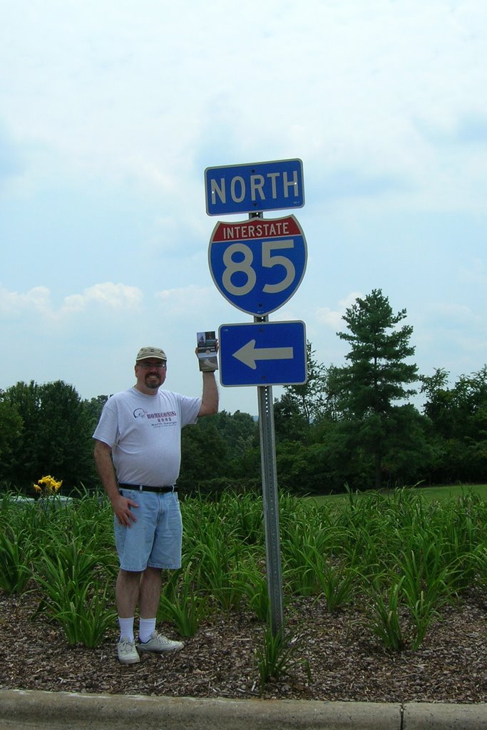
Steve at NC Welcome Center on I-85 NB (Photo taken by Mary Williams)
Today (Sunday, 8/27) at approximately 2:45 PM, just south of Greensboro, NC... I have now driven every mile of I-85 from Montgomery, AL, to Petersburg, VA!!! :)
Mary and I spent the last week in the Washington, DC, metro area. Other than "roadgeeking", we got to tour The White House, The Capitol, the Holocaust Museum, Arlington Cemetery, and the Smithsonian Air and Space and American History museums. We also visited Mount Vernon, saw Mary's old house in Chantilly (just south of the Dulles Airport), and did a lot of scenic driving and "roadgeeking". We also attended part of the Toastmasters International convention at the Hilton Washington. We actually stayed in Alexandria, VA, and took the DC Metro train for most of our DC visits. Kudos to the Metro for being convenient to most of the sites we visited.
Before reaching DC, we headed up US 29 to Charlottesville, VA, to visit Thomas Jefferson's Monticello and spend the night with her old friend Katherine. Thanks to Katherine, her husband Larry, and her mother Bunny for a wonderful time, plus a suggested scenic drive between Charlottesville and Fredericksburg that we took on our way to the DC area.
Besides clinching I-85, I also clinched I-295 in DC/Maryland, did some driving on I-64, I-66, I-81, I-395, I-495, and of course I-95 between I-85 and I-295 in Maryland. In addition to adding some new interstate driving mileage, I also added boatloads of new counties in DC, MD, NC, and VA, and even drove over the new Woodrow Wilson Bridge.
I took over 400 photos, and even Mary took several while we were on I-495 between Connecticut Avenue in Maryland to I-95/395 in Alexandria. Eventually, I'll go through them and share the best ones with y'all.
That's all for now. It's getting late, we've only been home since 8:30 PM, and I'm tired after nearly 12 hours on the road. Mary went to bed over an hour ago and I'm gonna join her.
Thanks for visiting and please come back again.
Saturday, August 12, 2006
The Old Dixie Highway In Adairsville
Last weekend, Mary and I went back to Subligna for her father's annual family reunion and Subligna Methodist Church homecoming.
On the way back home Sunday, we briefly stopped in Adairsville to get a photo of a Dixie Highway sign that we'd seen on GA 140 for the longest time. Since the sign on GA 140 was not in a good spot for a photo, we pulled off the road onto a street that turned out to be part of the old US 41... The Dixie Highway itself!!! :)
For your viewing pleasure, I have created a new page featuring the photos we took.
Next Saturday, we're heading to Washington, DC, and northern Virginia to see the sights and attend the Toastmasters convention. Since I'll be driving us up there and back, I'll be "clinching" a ton of new counties in Virginia, North Carolina, West Virginia (for Harper's Ferry), and hopefully at least one or two in Maryland. Oh yeah... by the time we get back, we will have "clinched" all of I-85!!! :)
That's all for now. Thanks for reading, hope you enjoy the photos, and please visit often.
Thursday, August 03, 2006
The GA 400 Survival Kit
This afternoon as I was making my way toward home, the traffic on both I-285 outer loop and GA 400 northbound was horrendous... even more than usual!!!
Thankfully, I had my ham radio rig in the truck and QSOing (talking) with fellow hams David, Hutch, Marshall, and James on the Atlanta Radio Club's (ARC) 146.82 MHz repeater really helped make the ride a little more bearable.
During my QSO with David, he mentioned that he avoids GA 400 whenever possible and I can't blame him for doing so. He even (jokingly) had the idea of a "GA 400 survival kit" that would include provisions (food, water, etc.) for all those long times one spends in traffic on that infamous Metro Atlanta road.
While I may not literally pack provisions, I am thankful for my own "survival kit", my ham radio rig... and for all the hams I talk to on both the ARC repeater and the Sawnee Mountain Amateur Group's 147.15 MHz repeater. You guys are great!!! :)
That's all for now. I'm getting ready for tomorrow and I'll be going to bed soon.
Thanks, dear reader, for visiting, reading, and for all your support.
Monday, July 31, 2006
The Videos Are Back
Since we now have boatloads of webserver space, we've uploaded our small collection of self-produced "roadgeek videos" for your viewing pleasure. Please click here for the video page.
That's all for tonight. Thanks for visiting and please come back often.
That's all for tonight. Thanks for visiting and please come back often.
Sunday, July 30, 2006
Website Changes
Dear Reader,
For future expansion of "The Georgia Road Geek", we have moved the non-blog website contents to our new web hosting service "Go Daddy".
As you may have noticed on the main page, we have made some website design changes, including a new main menu and a consolidated links page.
Thanks to "Go Daddy", we even have our own georgiaroadgeek.com e-mail accounts and have made it easier for you, the reader, to contact us. To e-mail us, please go to the main menu.
It's getting to be time for our afternoon "Sunday Siesta", so that's all for now. Thanks for reading and we hope you enjoy the new look and feel of "The Georgia Road Geek".
Friday, July 28, 2006
We Got A Response
Regarding the name change from "McFarland Road" to "McFarland Parkway", here's the response we received from the Forsyth County Roads and Bridges Department:
Mr. Williams,
On April 20, 2006 the Forsyth County Board of Commissioners re-named McFarland Road to McFarland Parkway. The Georgia Department of Transportation has modified the exist signs on SR 400, at the ramps, and at SR 9.
We will be changing out all the overhead signs along McFarland Road at the signalized locations.
Please let me know if you need any additional information from me regarding this change.
Tim Allen
Assistant Director of Engineering
My e-mail was sent to Mr. Douglas Armstrong, who promptly forwarded the inquiry to Mr. Allen. "The Georgia Road Geek" kindly thanks both these gentlemen for their timely response.
That's all for now. Thanks for reading and have a great weekend!
Wednesday, July 26, 2006
What's Up With That?
Today, as I made my way north up GA 400, I noticed that the Georgia DOT has replaced BGSes (that's "Big Green Signs") for McFarland Road (Exit 12 South/12A-B North) with new ones that say "McFarland Pkwy".
Forsyth County, who maintains this particular road, has not changed street signs... at least not yet.
Being "The Georgia Road Geek", my inquiring mind wants to know what's up with that, so I sent an e-mail to the Forsyth County Roads and Bridges Department. As soon as I get an answer, I'll share it with y'all.
In any event, this looks like yet another "roadgeek photo op", so I'll get a picture taken and post it for your viewing pleasure ASAP.
Has anyone else out there read the latest Atlanta Journal-Constitution (AJC) article regarding future roads and road improvements and the ideas of putting tolls on them? What's up with that? Click here to read it for yourself and please feel free to share your comments with us.
As I've said in past blogs, we have brought much of this mess upon ourselves by allowing development to get out-of-hand... and the politicians want us literally to pay to fix it with public-private initiative projects (PPIs) that will slap tolls on all newly constructed roads and newer lanes parallelling segments of existing roads. To our politicans, I say let's get a handle on the out-of-control growth first and foremost instead of just throwing money at projects that, at best, will be nothing but temporary "band-aids". Here's another AJC article listing the current PPIs proposed for Georgia.
That's all for now. Thanks for reading and please do so often.
Thursday, July 20, 2006
Our 15 Minutes Of Fame
The late Andy Warhol once said that everyone will get their "15 minutes of fame"... and we just got ours, thanks to the Roswell Neighbor.
Please click here to read the article written by Joan Durbin.
One minor point of clarification... I am 42, not 55. :)
Hope y'all enjoyed it, thanks for visiting and your support, and please visit often.
Please click here to read the article written by Joan Durbin.
One minor point of clarification... I am 42, not 55. :)
Hope y'all enjoyed it, thanks for visiting and your support, and please visit often.
Friday, July 14, 2006
My News Interview
A couple of weeks ago, the Roswell Neighbor newspaper ran a solicitation asking people about their commutes on GA 400 and what they do in their vehicle during such times.
Since I drive up and down GA 400 to and from work, I sent them an e-mail talking about my ham radio and roadgeeking... and they wanted to hear more!!! :)
Last Wednesday, I had a noon phone interview Joan Durbin. We had a real nice chat about what ham radio is, what we talk about on the ham radio, and last, but not least, my roadgeeking and what it's all about. During our interview, Joan was browsing this blogsite plus my "clinched" Interstate page. She was very fascinated as to why I was a self-proclaimed "roadgeek" and what led me to become such.
At 4:30 PM that same day, I met up with Skip, one of their photographers, at the Mansell MARTA Park and Ride lot off Exit 8 (Mansell Road), and he rode with me up GA 400 to Exit 10 (GA 120/Old Milton Parkway) and back, taking tons of pictures of me talking on my 2m VHF ham radio and the traffic jam in front of me. Before I dropped Skip off back at the Mansell lot, I gave him my e-mail address so that he could send me the photo(s) that they will use in the Roswell Neighbor.
As soon as the article comes out, I'll let y'all know.
Many thanks to Joan and Skip for their interest and time, my fellow ham radio operators for our QSOs (conversations) while Skip took pictures, and finally, thanks to you for reading and supporting "The Georgia Road Geek".
That's all for now. Have a great weekend!!!
Saturday, July 08, 2006
Pine Log Diversion
Last Monday, on our way back home from Subligna, Mary spotted a "See Rock City" barn on US 411/GA 61 just yards north of GA 140. She wanted to snap a picture of it and I happily obliged her. :) Here's the photo...
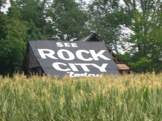
Just after snapping the pic, we ventured a little further north on US 411 and wound up turning at the tunnel bridge. There we spotted a green historical marker for the Pine Log United Methodist Church, so we went under the bridge to see the church. Here's a picture of the marker itself...
Not only did we see the church (a beautiful one at that), but we also got a look at the bridge, which is featured in J.T. Legg's Peach State Roads website. Here's our own photo of it...
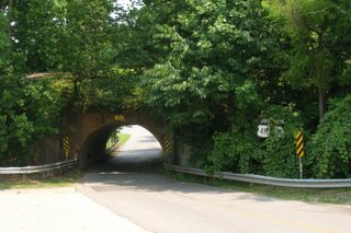
Here's also a closeup of the old "JUNCTION US 411/GA 61" sign...
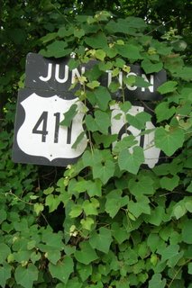
My wife wanted to move the kudzu, but I asked her to leave it "as is" for a somewhat "artistic" purpose. In today's vernacular, I wanted her to "keep it real". :)
For J.T. Legg's pictures and his perspective, please click here.
I'm glad my wife wanted to get a picture of the "See Rock City" barn. It also goes to show that when you venture off the beaten path sometimes, you never know what you'll encounter. Besides that and the old historic church, it was really neat to see the old tunnel bridge that I've only seen on J.T.'s website. In the end, I got a little history... and a little unexpected "extra roadgeeking" done.
That's all for now. Thanks for visiting and please do so often.
Monday, July 03, 2006
Mary's Scenic Byway

Yesterday (Sunday, 7/2/2006), my wife and I did a three-hour jaunt from Subligna and back as follows...
- Gore-Subligna Road to US 27/GA 1.
- US 27/GA 1 to GA 48 in Summerville.
- GA 48/AL 117 to I-59 (Exit 231) in Hammondville, AL.
- I-59 to GA 136 (Exit 11) in Trenton.
- GA 136 to East Armuchee Road.
- East Armuchee Road to Gore-Subligna Road.
Our first stop was in Summerville to see the railroad turntable that was installed in 2003 thanks to some federal transportation funding that almost did not happen due to the 9/11 attacks. Here's a photo we took...

After visiting the turntable, we proceeded west on GA 48 toward Alabama. This was the first of many scenic portions that we encountered, as GA 48 meandered its way over Lookout Mountain and on into Alabama, where it becomes AL 117.
Along AL 117 between the Georgia Line and I-59, we noticed that almost every road (including several dirt roads) were signed with blue pentagon county route markers. Here's an example (please pardon the photo quality)...
There were even some blue county route markers that contained the number but not the county name.
The next scenic view on AL 117 was found between Mentone and Valley Hill.
After stopping for gas in Valley Hill, we made our way to I-59, which we took from AL 117 (Exit 231) to GA 136 (Exit 11) in Trenton. At that point in our journey, we had "clinched" 2 new counties... DeKalb County, Alabama, and Dade County, Georgia!!! Here's the scene as we approached the Georgia state line on I-59...
Initially, I was planning to "clinch" all of I-59 in GA up to its end at I-24 and make my way eastward toward Chattanooga, but my wife suggested taking GA 136 (a.k.a. "Lookout Mountain Parkway") instead. Initially, I was relunctant, but I'm glad that I did so.... because the drive on GA 136 around Lookout Mountain from Dade into Walker County was really awesome with its breathtaking scenery and the "hairpin curves". IMHO, this is the best stretch of mountain road we've ever been on since driving the Russell-Brasstown Scenic Byway.
Back to the subject of county routes, we noticed that, in Dade County, the street signs all tended to have the Dade County route number along with the street or road name. In Georgia, county route numbers are marked with long green signs behind the "STOP" sign (if they are even marked at all), but I found Dade County's system somewhat interesting.
We finally left GA 136 at its 4-way intersection with GA 201 and East Armuchee Road (part of the Ridge and Valley Scenic Byway). In just under 3 hours time, we finally made it back to Subligna.
The only part of the drive that we were not fond of were the extremely narrow bridges we crossed along AL 117, but it looked like Alabama DOT was grading out land and getting ready to replace one of them in the Mentone/Valley Hill vicinity.
Overall, we considered this to be a very good scenic trip and highly recommend it for anyone interested in both scenery and roads.
In honor of my lovely wife, I, "The Georgia Road Geek", do hereby designate this entire route as "Mary's Scenic Byway"!!! :)
That's all for now. Thanks for reading and please come back again.
Saturday, July 01, 2006
Belated Birthday Greetings
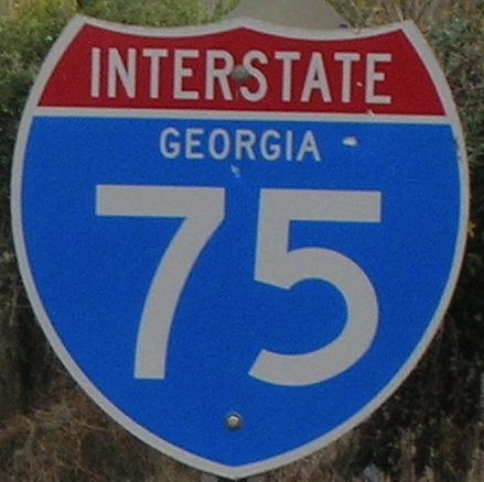
Dear readers, I was amiss in not posting a "Happy 50th Birthday" message yesterday to the Dwight D. Eisenhower Interstate System, so here goes....
Happy Birthday To You
Happy Birthday To You
Happy 50th Birthday Dwight D. Eisenhower Interstate System...
Happy Birthday To Yooooooooou.
... and many moooooore!!! :)
Last week, I had contemplated the idea of getting a birthday cake made for this occasion, but I did not follow through with it. If you did, or know of anyone else (besides state DOTs), then please let us know.
May y'all have a wonderful, happy, and safe 4th of July weekend.
Monday, June 26, 2006
4 Days And Counting!!!
As I write this blog, it is 4 more days until that great day in "roadgeekdom"... the Interstate Highway System's 50th Birthday!!!
Yesterday, the Georgia DOT began celebrations with a vintage car ride down I-75 from Windy Hill Road in Cobb County to The Varsity in Downtown Atlanta. To read more about this event, please click here for the article from the Atlanta Journal-Constitution.
At this very moment, a transcontinental convoy from San Francisco is travelling to Washington in commemoration of Dwight D. Eisenhower's 1919 military convoy, an event that helped shape the idea in his mind of a federal superhighway system. Thanks to modern-day GPS technology, you can see where the convoy is currently located courtesy of AASHTO. Click here for updates.
National City Network features webcasts of the historic convoy. Click here to see for yourself (NOTE: DSL or better connections work best.)
The public radio program "Living On Earth" recently interviewed Interstate expert and author Dan McNichol as he traveled down I-90. Please click here for a transcript and audio.
Yes, folks, the "Big 5-0" is approaching quick and we, your friends at "The Georgia Road Geek", encourage you to take a moment of your time to reflect on how the Interstate Highway System has affected your life and your travels down both the literal highways and the proverbial "highway of life".
Finally, I'd like to give a special "thank you" to my dad, for letting me be his "navigator". When I was a child, he would hand me the maps and I would help him get to one of our many vacation destinations. This helped give me an appreciation of America's various and sundry roads and highways. I guess I was a "roadgeek" before I found out what one was. :)
That's all for now. Thanks for reading and please come back again.
Saturday, June 24, 2006
New GDOT Large Print Roadmaps
Fellow Road Enthusiasts,
According to a press release dated June 22, 2006, the Georgia DOT (GDOT) now has a "large print" state map which is being released to the state's welcome centers via the Georgia Department of Economic Development.
However, according to GDOT, you can get a "limited first edition" of this new map by contacting them directly. Their Map Sales unit e-mail address is OTDCustomerSrv@dot.state.ga.us.
Just before composing this blog, I e-mailed GDOT and put in a request. Once I receive the map, I'll look it over and give you my thoughts in a follow-up blog.
T0 read the full GDOT press release, please click here.
In other "Georgia Road Geek" news...
US 19/GA 400 construction in North Fulton and South Forsyth counties is really picking up the pace, with the median graded out and graveled/asphalted (and even some new "Jersey Barriers") between GA 14o/Holcomb Bridge Road (Exit 7) and GA 120/Old Milton Parkway (Exit 10), plus new northbound shoulder work being done between Windward Parkway (Exit 11) and McFarland Road (Exit 12). On the southbound lanes of GA 400 between McFarland and Windward, shoulder work has been completed. It has also been striped for temporary use as the rightmost lane during the ongoing widening process.
At the Haynes Bridge Road (Exit 9) acceleration ramp to GA 400 northbound, I've noticed several brand new BGSes that may be going up soon. They are currently sitting in racks, so I can't make out what they say.
In the meantime, contact GDOT for your "limited first edition" print map.
Finally, here's a "shout out" to my brother-in-law Lib for plugging my blog via his blog "The Smith Family Website". Thanks, Lib, for your kind words and support. I love you, man!!! :)
That's all for now. Thanks for visiting and please do so often.
Friday, June 16, 2006
Classic City Roadgeeking
For the past 3 days, Mary and I were in Athens (a.k.a. "The Classic City") at the North Georgia United Methodists annual conference, which was held at The Classic Center.
When we didn't have to be in business or worship sessions, we took a walk around Downtown Athens to see the sights... and yes, do some "Classic City roadgeeking" (as you can see from the photo below)...
 One of the sights we saw during one of our short ventures was the famous Confederate double-barreled cannon. This cannon never worked as intended since no one could get the barrels to fire simultaneously, but it sits in front of the Athens City Hall and symbolically points northward. Here's a shot of me next to this famous piece of artillery...

When we didn't have to be in business or worship sessions, we took a walk around Downtown Athens to see the sights... and yes, do some "Classic City roadgeeking" (as you can see from the photo below)...
One of the sights we saw during one of our short ventures was the famous Confederate double-barreled cannon. This cannon never worked as intended since no one could get the barrels to fire simultaneously, but it sits in front of the Athens City Hall and symbolically points northward. Here's a shot of me next to this famous piece of artillery...After the conference ended this afternoon, we set out on the final "classic roadgeek mission"... clinch 2 more counties.
First, we traveled eastward on US 78 Business/US 78/GA 10 into Oglethorpe County. Once we crossed the line and turned around, we headed toward our second county... Madison. While crossing back into Athens/Clarke County, we noticed that the sign on US 78/GA 10 westbound simply said "Clarke County" instead of "Athens-Clarke County". Here's the photo...

To clinch Madison County, we headed to the Athens Perimeter/Paul Broun Parkway (GA 10 Loop/GA 422) and proceeded northward. At the northeastern corner of the Perimeter, US 29/GA 8 continues northward and we followed it into Madison County (but not before stopping at the Burger King at the corner of US 29/GA 8 and GA 72 for a quick lunch break).
After lunch, we proceeded northward... and clinched Madison County. MISSION ACCOMPLISHED!!! :)
We then headed back to Atlanta following US 29/GA 8 along the inner Athens Perimeter to GA 316. Incidentally, the US and other GA routes that follow the eastern and southern sections of the Perimeter were not shown on assurance markers. Here's an example...

You could, however, see the US route markers on the overhead BGSes. For BGS pictures, please see J.T. Legg's Peach State Roads GA 10 Loop webpage. BTW, GA 422 is not marked anywhere along the stretch that we traveled, thus it is apparently "secret" just like the 400-series Interstates.
On the last leg of our journey home, I did manage to take some pictures of the construction at the I-85/GA 316 merge and I'll share those with y'all soon.
I do need to mention one more thing... on the day of our 3rd wedding anniversary (Wednesday), we celebrated by eating dinner at The Varsity-Athens. It was her first time eating at a Varsity and we just loooooved those greasy, greasy onion rings (along with our dogs). To celebrate and commemorate Mary's first real Varsity experience, here's the photo I took of her with her empty onion ring boats... That's all for now. Thanks for reading and please come back again.
Saturday, June 10, 2006
Our Subligna Trip
Last weekend, we went up to Mary's parents' farm in the Subligna area and had a wonderful time visiting her folks.
Subligna, located in northeastern Chattooga County, is located miles from any highway and is one of the most isolated places we've ever been to in Georgia... but for what it lacks in amenities, it more than makes up for it in utter beauty, peace, and quiet. Every chance we get, we pack up the car and spend a weekend in that wonderful little getaway place of ours. :)
As promised, I took a load of road pictures. Here is one of them for your viewing pleasure...
With most US highways in Georgia, you get to see the corresponding state route number with it. Sometimes on the assurance marker post, you may see the GA route given precedence over the US route number, such as the one above in Chattooga County. Incidentally, this reflects a newer Georgia design and a smaller US route shield which are becoming much more common on Georgia's highways.
US 27/GA 1 (GRIP corridor EDS-27), from GA 156 to Gore-Subligna Road, is part of a National Forest Scenic Byway (NFSBW) designated by the Georgia DOT as the Ridge and Valley Scenic Byway. Interestingly enough, there are no signs telling you this, but instead, you see generic NFSBW signs along its route and you wouldn't know this name unless you either had looked at an official Georgia map from a couple of years back or visited the Georgia DOT website.
Before writing this blog, I took some of the photos I had taken along this route and compiled them into a photo album. Please click here to see them.
I also took photos of the ends of GA 140 and GA 156 at US 27/GA 1 as follows...


Subligna, located in northeastern Chattooga County, is located miles from any highway and is one of the most isolated places we've ever been to in Georgia... but for what it lacks in amenities, it more than makes up for it in utter beauty, peace, and quiet. Every chance we get, we pack up the car and spend a weekend in that wonderful little getaway place of ours. :)
As promised, I took a load of road pictures. Here is one of them for your viewing pleasure...

With most US highways in Georgia, you get to see the corresponding state route number with it. Sometimes on the assurance marker post, you may see the GA route given precedence over the US route number, such as the one above in Chattooga County. Incidentally, this reflects a newer Georgia design and a smaller US route shield which are becoming much more common on Georgia's highways.
US 27/GA 1 (GRIP corridor EDS-27), from GA 156 to Gore-Subligna Road, is part of a National Forest Scenic Byway (NFSBW) designated by the Georgia DOT as the Ridge and Valley Scenic Byway. Interestingly enough, there are no signs telling you this, but instead, you see generic NFSBW signs along its route and you wouldn't know this name unless you either had looked at an official Georgia map from a couple of years back or visited the Georgia DOT website.
Before writing this blog, I took some of the photos I had taken along this route and compiled them into a photo album. Please click here to see them.
I also took photos of the ends of GA 140 and GA 156 at US 27/GA 1 as follows...
Please click here for a full map of the Ridge and Valley Scenic Byway from GDOT (in PDF form).
That's all for now. Thanks for visiting and please come back again.
Saturday, June 03, 2006
Subligna, Here We Come!!!
Today, Mary and I are going to the great Chattooga County metropolis of Subligna.
My in-laws live on a farm there and we're gonna spend the rest of the weekend there with them. Mary is going to cook a nice meal for them... and boy is it gonna be nice. I'm sure her folks will enjoy it. :)
On June 14, 2003, we were married there on the farm by her father, a retired Methodist minister who grew up there. Here's one of many photos of our wedding day...

Speaking of weddings, congratulations to fellow road enthusiast Brian LeBlanc and his bride Laura on their recent wedding. May theirs be a happy and prosperous one!!! :)
My in-laws live on a farm there and we're gonna spend the rest of the weekend there with them. Mary is going to cook a nice meal for them... and boy is it gonna be nice. I'm sure her folks will enjoy it. :)
On June 14, 2003, we were married there on the farm by her father, a retired Methodist minister who grew up there. Here's one of many photos of our wedding day...
Speaking of weddings, congratulations to fellow road enthusiast Brian LeBlanc and his bride Laura on their recent wedding. May theirs be a happy and prosperous one!!! :)
My roadgeek objective for this trip is to get at least one picture of the end of GA 140 at US 27/GA 1 in Floyd County, plus any others that I can on the way there.
That's all for now. It's time to get ready to go to Subligna. Kudos again to our newest "roadgeek couple" Brian and Laura, thanks to y'all for reading, and may y'all have a great weekend.
Subscribe to:
Comments (Atom)
