
Yesterday (Sunday, 7/2/2006), my wife and I did a three-hour jaunt from Subligna and back as follows...
- Gore-Subligna Road to US 27/GA 1.
- US 27/GA 1 to GA 48 in Summerville.
- GA 48/AL 117 to I-59 (Exit 231) in Hammondville, AL.
- I-59 to GA 136 (Exit 11) in Trenton.
- GA 136 to East Armuchee Road.
- East Armuchee Road to Gore-Subligna Road.
Our first stop was in Summerville to see the railroad turntable that was installed in 2003 thanks to some federal transportation funding that almost did not happen due to the 9/11 attacks. Here's a photo we took...

After visiting the turntable, we proceeded west on GA 48 toward Alabama. This was the first of many scenic portions that we encountered, as GA 48 meandered its way over Lookout Mountain and on into Alabama, where it becomes AL 117.
Along AL 117 between the Georgia Line and I-59, we noticed that almost every road (including several dirt roads) were signed with blue pentagon county route markers. Here's an example (please pardon the photo quality)...
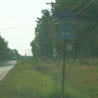
There were even some blue county route markers that contained the number but not the county name.
The next scenic view on AL 117 was found between Mentone and Valley Hill.
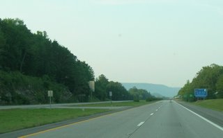
After stopping for gas in Valley Hill, we made our way to I-59, which we took from AL 117 (Exit 231) to GA 136 (Exit 11) in Trenton. At that point in our journey, we had "clinched" 2 new counties... DeKalb County, Alabama, and Dade County, Georgia!!! Here's the scene as we approached the Georgia state line on I-59...
Initially, I was planning to "clinch" all of I-59 in GA up to its end at I-24 and make my way eastward toward Chattanooga, but my wife suggested taking GA 136 (a.k.a. "Lookout Mountain Parkway") instead. Initially, I was relunctant, but I'm glad that I did so.... because the drive on GA 136 around Lookout Mountain from Dade into Walker County was really awesome with its breathtaking scenery and the "hairpin curves". IMHO, this is the best stretch of mountain road we've ever been on since driving the Russell-Brasstown Scenic Byway.
Back to the subject of county routes, we noticed that, in Dade County, the street signs all tended to have the Dade County route number along with the street or road name. In Georgia, county route numbers are marked with long green signs behind the "STOP" sign (if they are even marked at all), but I found Dade County's system somewhat interesting.
We finally left GA 136 at its 4-way intersection with GA 201 and East Armuchee Road (part of the Ridge and Valley Scenic Byway). In just under 3 hours time, we finally made it back to Subligna.
The only part of the drive that we were not fond of were the extremely narrow bridges we crossed along AL 117, but it looked like Alabama DOT was grading out land and getting ready to replace one of them in the Mentone/Valley Hill vicinity.
Overall, we considered this to be a very good scenic trip and highly recommend it for anyone interested in both scenery and roads.
In honor of my lovely wife, I, "The Georgia Road Geek", do hereby designate this entire route as "Mary's Scenic Byway"!!! :)
That's all for now. Thanks for reading and please come back again.

No comments:
Post a Comment